
Make a donation
Gear up for your next adventure:
As an Amazon Associate, this site earns from qualifying purchases at no extra cost to you.
Damon topographic map
Click on the map to display elevation.
Make a donation
Gear up for your next adventure:
As an Amazon Associate, this site earns from qualifying purchases at no extra cost to you.
About this map
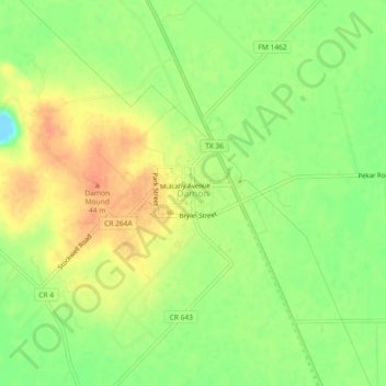
Name: Damon topographic map, elevation, terrain.
Location: Damon, Brazoria County, Texas, United States (29.27052 -95.75467 29.31052 -95.71467)
Average elevation: 25 m
Minimum elevation: -2 m
Maximum elevation: 45 m
Make a donation
Gear up for your next adventure:
As an Amazon Associate, this site earns from qualifying purchases at no extra cost to you.
Other topographic maps
Click on a map to view its topography, its elevation and its terrain.
Danbury
United States > Texas > Brazoria County
In 2006, the average elevation was 21.4 feet (6.5 m) above mean sea level (MSL), which reflects a 0.168-inch (4.3 mm) negative deviation compared to a 1998 study. This decrease is believed to be caused by the extraction of groundwater (9% of total declination), the extraction of petroleum products (88% of…
Average elevation: 8 m
Make a donation
Gear up for your next adventure:
As an Amazon Associate, this site earns from qualifying purchases at no extra cost to you.
Make a donation
Gear up for your next adventure:
As an Amazon Associate, this site earns from qualifying purchases at no extra cost to you.
Make a donation
Gear up for your next adventure:
As an Amazon Associate, this site earns from qualifying purchases at no extra cost to you.
Make a donation
Gear up for your next adventure:
As an Amazon Associate, this site earns from qualifying purchases at no extra cost to you.
Make a donation
Gear up for your next adventure:
As an Amazon Associate, this site earns from qualifying purchases at no extra cost to you.