
Make a donation
Gear up for your next adventure:
As an Amazon Associate, this site earns from qualifying purchases at no extra cost to you.
Gescher topographic map
Click on the map to display elevation.
Make a donation
Gear up for your next adventure:
As an Amazon Associate, this site earns from qualifying purchases at no extra cost to you.
About this map
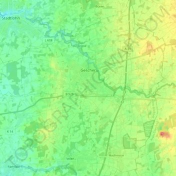
Name: Gescher topographic map, elevation, terrain.
Location: Gescher, Kreis Borken, North Rhine-Westphalia, 48712, Germany (51.88367 6.92557 52.00498 7.09019)
Average elevation: 64 m
Minimum elevation: 44 m
Maximum elevation: 103 m
Make a donation
Gear up for your next adventure:
As an Amazon Associate, this site earns from qualifying purchases at no extra cost to you.
Other topographic maps
Click on a map to view its topography, its elevation and its terrain.
Make a donation
Gear up for your next adventure:
As an Amazon Associate, this site earns from qualifying purchases at no extra cost to you.
Isselburg
Germany > North Rhine-Westphalia > Kreis Borken > Isselburg > Isselburg
Average elevation: 19 m
Zwillbrock
Germany > North Rhine-Westphalia > Kreis Borken > Vreden > Zwillbrock
Average elevation: 31 m
Make a donation
Gear up for your next adventure:
As an Amazon Associate, this site earns from qualifying purchases at no extra cost to you.