
Make a donation
Gear up for your next adventure:
As an Amazon Associate, this site earns from qualifying purchases at no extra cost to you.
Verlot topographic map
Click on the map to display elevation.
Make a donation
Gear up for your next adventure:
As an Amazon Associate, this site earns from qualifying purchases at no extra cost to you.
About this map
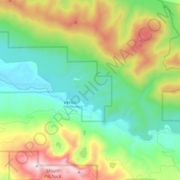
Name: Verlot topographic map, elevation, terrain.
Location: Verlot, Snohomish County, Washington, United States (48.06972 -121.81926 48.11939 -121.68869)
Average elevation: 712 m
Minimum elevation: 269 m
Maximum elevation: 1,602 m
Make a donation
Gear up for your next adventure:
As an Amazon Associate, this site earns from qualifying purchases at no extra cost to you.
Other topographic maps
Click on a map to view its topography, its elevation and its terrain.
Make a donation
Gear up for your next adventure:
As an Amazon Associate, this site earns from qualifying purchases at no extra cost to you.
Make a donation
Gear up for your next adventure:
As an Amazon Associate, this site earns from qualifying purchases at no extra cost to you.
Make a donation
Gear up for your next adventure:
As an Amazon Associate, this site earns from qualifying purchases at no extra cost to you.
Granite Falls
United States > Washington > Snohomish County > Granite Falls > Granite Falls
Average elevation: 143 m
Make a donation
Gear up for your next adventure:
As an Amazon Associate, this site earns from qualifying purchases at no extra cost to you.
Totem Park
United States > Washington > Snohomish County > Arlington > Totem Park
Average elevation: 34 m
Mill Creek
United States > Washington > Snohomish County > Mill Creek > Mill Creek
Average elevation: 129 m
Snohomish
United States > Washington > Snohomish County > Snohomish > Snohomish
Average elevation: 36 m
Make a donation
Gear up for your next adventure:
As an Amazon Associate, this site earns from qualifying purchases at no extra cost to you.