
Make a donation
Gear up for your next adventure:
As an Amazon Associate, this site earns from qualifying purchases at no extra cost to you.
Ringelstein topographic map
Click on the map to display elevation.
Make a donation
Gear up for your next adventure:
As an Amazon Associate, this site earns from qualifying purchases at no extra cost to you.
About this map
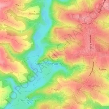
Name: Ringelstein topographic map, elevation, terrain.
Average elevation: 173 m
Minimum elevation: 110 m
Maximum elevation: 220 m
Make a donation
Gear up for your next adventure:
As an Amazon Associate, this site earns from qualifying purchases at no extra cost to you.
Other topographic maps
Click on a map to view its topography, its elevation and its terrain.
Eischeid
Deutschland > Nordrhein-Westfalen > Rhein-Sieg-Kreis > Neunkirchen-Seelscheid
Average elevation: 187 m
Wolperath
Deutschland > Nordrhein-Westfalen > Rhein-Sieg-Kreis > Neunkirchen-Seelscheid
Average elevation: 175 m
Seelscheid
Deutschland > Nordrhein-Westfalen > Rhein-Sieg-Kreis > Neunkirchen-Seelscheid > Hausen
Average elevation: 191 m
53819
Deutschland > Nordrhein-Westfalen > Rhein-Sieg-Kreis > Neunkirchen-Seelscheid > Niederwennerscheid
Average elevation: 190 m
Make a donation
Gear up for your next adventure:
As an Amazon Associate, this site earns from qualifying purchases at no extra cost to you.