
Thambilideniya topographic map
Interactive map
Click on the map to display elevation.
About this map
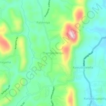
Name: Thambilideniya topographic map, elevation, terrain.
Location: Thambilideniya, Matale District, Central Province, Sri Lanka (7.57673 80.59186 7.61673 80.63186)
Average elevation: 419 m
Minimum elevation: 333 m
Maximum elevation: 627 m
Other topographic maps
Click on a map to view its topography, its elevation and its terrain.
Matale District
Matale District, Central Province, Sri Lanka
Average elevation: 270 m
Lewella Junction
Sri Lanka > Central Province > Kandy > Lewella Junction
Lewella Junction, Kandy, Kandy District, Central Province, 2000, Sri Lanka
Average elevation: 531 m
Kandy
Sri Lanka > Central Province > Kandy
Kandy, Kandy District, Central Province, 20000, Sri Lanka
Average elevation: 621 m
Nattarampota
Sri Lanka > Central Province > Nattarampota
Nattarampota, Kandy District, Central Province, 60622, Sri Lanka
Average elevation: 498 m