
Newport topographic map
Interactive map
Click on the map to display elevation.
About this map
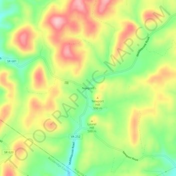
Name: Newport topographic map, elevation, terrain.
Location: Newport, Augusta County, Virginia, 24459, United States (37.98096 -79.32087 38.02096 -79.28087)
Average elevation: 564 m
Minimum elevation: 474 m
Maximum elevation: 658 m
Other topographic maps
Click on a map to view its topography, its elevation and its terrain.
Augusta Springs
United States > Virginia > Augusta County
Augusta Springs, Augusta County, Virginia, 24411, United States
Average elevation: 550 m
Mount Sidney
United States > Virginia > Augusta County
Mount Sidney, Augusta County, Virginia, 24467, United States
Average elevation: 415 m
Fort Defiance
United States > Virginia > Augusta County
Fort Defiance, Augusta County, Virginia, 24467, United States
Average elevation: 405 m
Mount Solon
United States > Virginia > Augusta County
Mount Solon, Augusta County, Virginia, 22843, United States
Average elevation: 426 m
Steeles Tavern
United States > Virginia > Augusta County
Steeles Tavern, Augusta County, Virginia, 24472, United States
Average elevation: 523 m
Weyers Cave
United States > Virginia > Augusta County > Weyers Cave
Weyers Cave, Augusta County, Virginia, 24486, United States
Average elevation: 364 m
Craigsville
United States > Virginia > Augusta County
Craigsville, Augusta County, Virginia, United States
Average elevation: 519 m
Greenville
United States > Virginia > Augusta County
Greenville, Augusta County, Virginia, 24440, United States
Average elevation: 508 m
Deerfield
United States > Virginia > Augusta County
Deerfield, Augusta County, Virginia, 24432, United States
Average elevation: 577 m
Natural Chimneys Park & Campground
United States > Virginia > Augusta County
Natural Chimneys Park & Campground, Augusta County, Virginia, 22843, United States
Average elevation: 421 m
Jolivue
United States > Virginia > Augusta County
Jolivue, Augusta County, Virginia, United States
Average elevation: 476 m
Dooms
United States > Virginia > Augusta County
Dooms, Augusta County, Virginia, United States
Average elevation: 440 m
Upper Sherando Lake
United States > Virginia > Augusta County
Upper Sherando Lake, Augusta County, Virginia, United States
Average elevation: 672 m
West Augusta
United States > Virginia > Augusta County
West Augusta, Augusta County, Virginia, 24485, United States
Average elevation: 632 m
South River
United States > Virginia > Augusta County > Crimora
South River, Crimora, Augusta County, Virginia, 22980, United States
Average elevation: 466 m
Fishersville
United States > Virginia > Augusta County
Fishersville, Augusta County, Virginia, 22939, United States
Average elevation: 417 m
Middlebrook
United States > Virginia > Augusta County
Middlebrook, Augusta County, Virginia, United States
Average elevation: 593 m
Stuarts Draft
United States > Virginia > Augusta County
Stuarts Draft, Augusta County, Virginia, 24477, United States
Average elevation: 458 m
Verona
United States > Virginia > Augusta County > Verona
Verona, Augusta County, Virginia, 24482, United States
Average elevation: 405 m
Churchville
United States > Virginia > Augusta County
Churchville, Augusta County, Virginia, 24421, United States
Average elevation: 467 m
Lyndhurst
United States > Virginia > Augusta County
Lyndhurst, Augusta County, Virginia, United States
Average elevation: 437 m
Swoope
United States > Virginia > Augusta County
Swoope, Augusta County, Virginia, 24479, United States
Average elevation: 503 m
Crimora
United States > Virginia > Augusta County > Crimora
Crimora, Augusta County, Virginia, 24431, United States
Average elevation: 409 m