
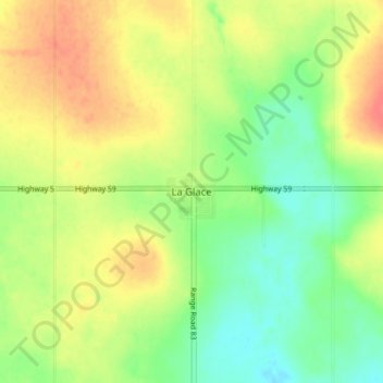
La Glace topographic map
Interactive map
Click on the map to display elevation.
About this map
Name: La Glace topographic map, elevation, terrain.
Location: La Glace, Division No. 19, Alberta, T0H 2J0, Canada (55.38296 -119.17437 55.42296 -119.13437)
Average elevation: 738 m
Minimum elevation: 713 m
Maximum elevation: 764 m
La Glace is a hamlet in northern Alberta, Canada within the County of Grande Prairie No. 1. It is located along Highway 59 between Sexsmith and Valhalla Centre and has an elevation of 735 metres (2,411 ft).
Other topographic maps
Click on a map to view its topography, its elevation and its terrain.
Clairmont
Canada > Alberta > Division No. 19 > Hamlet of Clairmont
Clairmont, Hamlet of Clairmont, Division No. 19, Alberta, T0H 0W0, Canada
Average elevation: 679 m
Village of Donnelly
Canada > Alberta > Division No. 19
Village of Donnelly, Division No. 19, Alberta, Canada
Average elevation: 594 m
Grande Prairie
Canada > Alberta > Division No. 19
Grande Prairie, Division No. 19, Alberta, Canada
Average elevation: 665 m
Beaverlodge
Canada > Alberta > Division No. 19
Beaverlodge, Division No. 19, Alberta, T0H 0C0, Canada
Average elevation: 735 m