
张掖丹霞国家地质公园 topographic map
Interactive map
Click on the map to display elevation.
About this map
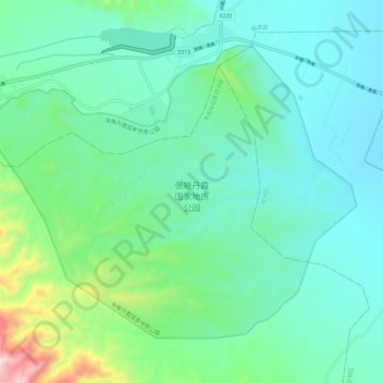
Name: 张掖丹霞国家地质公园 topographic map, elevation, terrain.
Location: 张掖丹霞国家地质公园, 肃南裕固族自治县, 张掖市, 甘肃省, 734400, 中国 (38.91919 100.02120 38.98835 100.13720)
Average elevation: 1,759 m
Minimum elevation: 1,605 m
Maximum elevation: 2,379 m
临泽丹霞景区是公园的核心区域,距张掖市区以西30公里(19英里),临泽县城以南20公里(12英里)。这是整个公园发展最为完善,游客人数最多的一个景区。 第二大景区冰沟位于梨园河北岸,于2014年8月3日正式揭牌。 冰沟占地总面积为300平方公里(120平方英里),海拔1500-2500米。 第三大景区肃南丹霞景区位于甘肃省临泽县。
Other topographic maps
Click on a map to view its topography, its elevation and its terrain.