
碧鸡街道 topographic map
Interactive map
Click on the map to display elevation.
About this map
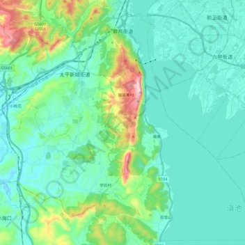
Name: 碧鸡街道 topographic map, elevation, terrain.
Location: 碧鸡街道, 西山区, 昆明市, 云南省, 中国 (24.81700 102.57829 25.00990 102.73696)
Average elevation: 1,964 m
Minimum elevation: 1,844 m
Maximum elevation: 2,506 m
Other topographic maps
Click on a map to view its topography, its elevation and its terrain.