
Make a donation
Gear up for your next adventure:
As an Amazon Associate, this site earns from qualifying purchases at no extra cost to you.
Kendari topographic map
Click on the map to display elevation.
Make a donation
Gear up for your next adventure:
As an Amazon Associate, this site earns from qualifying purchases at no extra cost to you.
Kendari
Kendari borders the Konawe Regency in the north, South Konawe Regency in the south and west, and Kendari Bay in the east. The city is on the southeastern part of mainland Sulawesi island; several smaller islands around the bay are within its boundaries. The city's topography varies from flat to hilly. Coastal areas tend to be flatter, while the northern part of the city is part of the Nipa-Nipa mountain formation, which reaches elevations of approximately 450 metres (1,480 ft). In general, the city's slopes are less than 25 percent except for those in the north, which in some places exceed 40 percent.
Make a donation
Gear up for your next adventure:
As an Amazon Associate, this site earns from qualifying purchases at no extra cost to you.
About this map
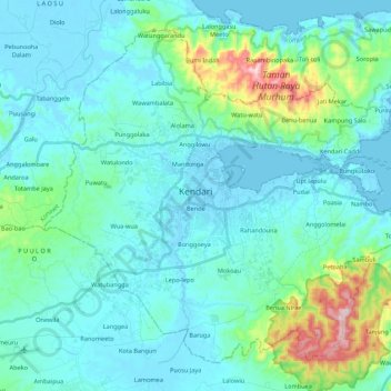
Name: Kendari topographic map, elevation, terrain.
Location: Kendari, Southeast Sulawesi, Sulawesi, Indonesia (-4.08695 122.43383 -3.90143 122.65081)
Average elevation: 67 m
Minimum elevation: -3 m
Maximum elevation: 446 m
Make a donation
Gear up for your next adventure:
As an Amazon Associate, this site earns from qualifying purchases at no extra cost to you.
Other topographic maps
Click on a map to view its topography, its elevation and its terrain.