
Make a donation
Gear up for your next adventure:
As an Amazon Associate, this site earns from qualifying purchases at no extra cost to you.
Gosford topographic map
Click on the map to display elevation.
Make a donation
Gear up for your next adventure:
As an Amazon Associate, this site earns from qualifying purchases at no extra cost to you.
About this map
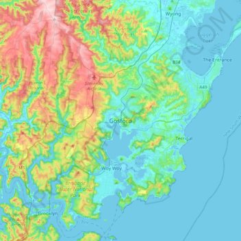
Name: Gosford topographic map, elevation, terrain.
Average elevation: 75 m
Minimum elevation: -4 m
Maximum elevation: 349 m
Make a donation
Gear up for your next adventure:
As an Amazon Associate, this site earns from qualifying purchases at no extra cost to you.
Other topographic maps
Click on a map to view its topography, its elevation and its terrain.
Sydney
Sydney's topography is characterized by a diverse landscape that seamlessly blends coastal features with inland plateaus. The city is divided into two primary regions: the relatively flat Cumberland Plain to the south and west of Sydney Harbour, and the elevated Hornsby Plateau to the north. The Cumberland…
Average elevation: 53 m
Make a donation
Gear up for your next adventure:
As an Amazon Associate, this site earns from qualifying purchases at no extra cost to you.
Goulburn
Owing to its elevation, Goulburn has an oceanic climate (Cfb) with warm summers and cool winters; with a high diurnal range. Its climate is variable much of the year, though generally dry with maximum temperatures ranging from 11.8 °C (53.2 °F) in July to 28.3 °C (82.9 °F) in January. Rainfall is…
Average elevation: 666 m
Make a donation
Gear up for your next adventure:
As an Amazon Associate, this site earns from qualifying purchases at no extra cost to you.
Byron Bay
Byron Bay, located in northeastern New South Wales, Australia, is characterized by diverse topography shaped by its geological history. The town is part of the erosion caldera of the ancient Tweed Volcano, which erupted approximately 23 million years ago, resulting in the rich volcanic soils that define the…
Average elevation: 7 m
Make a donation
Gear up for your next adventure:
As an Amazon Associate, this site earns from qualifying purchases at no extra cost to you.
Make a donation
Gear up for your next adventure:
As an Amazon Associate, this site earns from qualifying purchases at no extra cost to you.
Make a donation
Gear up for your next adventure:
As an Amazon Associate, this site earns from qualifying purchases at no extra cost to you.
Blue Mountains
A sandstone plateau dominated by a landscape of endless eucalyptus forests, the Blue Mountains are located at the top of a 470-million-year-old quartzite. In the Permian period, a shallow sea covered the region, when rivers brought shales, siltstones and mudstones. Then during the Mesozoic period, rivers…
Average elevation: 566 m
Grose Valley
Australia > New South Wales > Blackheath
The bulk of the vegetation in the wilderness is dry open forest and woodland, dominated by Eucalyptus sieberi and E. piperita above 800 metres (2,600 ft) altitude with Eucalyptus oblonga, E. globoidea, E. agglomerata and Angophora costata becoming dominant at lower altitudes. Plateau areas have thinner or…
Average elevation: 833 m
Make a donation
Gear up for your next adventure:
As an Amazon Associate, this site earns from qualifying purchases at no extra cost to you.
Yass
Yass is located 280 km south-west of Sydney, on the Hume Highway. The Yass River, which is a tributary of the Murrumbidgee River, flows through the town. Yass is 59 km from Canberra; lying at an elevation of 505 m AMSL.
Average elevation: 533 m
Blackheath
Blackheath (postcode: 2785) is an Australian town located near the highest point of the Blue Mountains, between Katoomba and Mount Victoria in New South Wales. The town's altitude is about 1,065 metres (3,494 ft) AHD and it is located about 120 kilometres (75 mi) west north-west of Sydney, 11 kilometres…
Average elevation: 893 m
Make a donation
Gear up for your next adventure:
As an Amazon Associate, this site earns from qualifying purchases at no extra cost to you.
Make a donation
Gear up for your next adventure:
As an Amazon Associate, this site earns from qualifying purchases at no extra cost to you.
Orange
Orange is a city in the Central Tablelands region of New South Wales, Australia. It is 254 km (158 mi) west of the state capital, Sydney [206 km (128 mi) on a great circle], at an altitude of 862 metres (2,828 ft). Orange had an estimated urban population of 40,493 as of June 2018 making the city a significant…
Average elevation: 852 m
Make a donation
Gear up for your next adventure:
As an Amazon Associate, this site earns from qualifying purchases at no extra cost to you.
Make a donation
Gear up for your next adventure:
As an Amazon Associate, this site earns from qualifying purchases at no extra cost to you.
Sydney
Sydney's topography is characterized by a diverse landscape that seamlessly blends coastal features with inland plateaus. The city is divided into two primary regions: the relatively flat Cumberland Plain to the south and west of Sydney Harbour, and the elevated Hornsby Plateau to the north. The Cumberland…
Average elevation: 53 m
Make a donation
Gear up for your next adventure:
As an Amazon Associate, this site earns from qualifying purchases at no extra cost to you.
Make a donation
Gear up for your next adventure:
As an Amazon Associate, this site earns from qualifying purchases at no extra cost to you.
Hazelbrook
Hazelbrook is a town in New South Wales, Australia (Elevation: 675 metres) It is located 91 kilometres west of Sydney and 16 kilometres east of Katoomba in the Blue Mountains on the Great Western Highway.
Average elevation: 610 m
Make a donation
Gear up for your next adventure:
As an Amazon Associate, this site earns from qualifying purchases at no extra cost to you.
Make a donation
Gear up for your next adventure:
As an Amazon Associate, this site earns from qualifying purchases at no extra cost to you.
Make a donation
Gear up for your next adventure:
As an Amazon Associate, this site earns from qualifying purchases at no extra cost to you.
Make a donation
Gear up for your next adventure:
As an Amazon Associate, this site earns from qualifying purchases at no extra cost to you.
Paddington
Paddington is a rare and largely intact example of an early Victorian residential suburb. Its unique qualities may be attributed to its close proximity to the city, the topography of its harbour location, the process of development and subdivision of early land grants, and the short period in the late l9thC in…
Average elevation: 42 m
Make a donation
Gear up for your next adventure:
As an Amazon Associate, this site earns from qualifying purchases at no extra cost to you.
Make a donation
Gear up for your next adventure:
As an Amazon Associate, this site earns from qualifying purchases at no extra cost to you.
Make a donation
Gear up for your next adventure:
As an Amazon Associate, this site earns from qualifying purchases at no extra cost to you.
Make a donation
Gear up for your next adventure:
As an Amazon Associate, this site earns from qualifying purchases at no extra cost to you.
Make a donation
Gear up for your next adventure:
As an Amazon Associate, this site earns from qualifying purchases at no extra cost to you.
Make a donation
Gear up for your next adventure:
As an Amazon Associate, this site earns from qualifying purchases at no extra cost to you.
Make a donation
Gear up for your next adventure:
As an Amazon Associate, this site earns from qualifying purchases at no extra cost to you.
Make a donation
Gear up for your next adventure:
As an Amazon Associate, this site earns from qualifying purchases at no extra cost to you.
Make a donation
Gear up for your next adventure:
As an Amazon Associate, this site earns from qualifying purchases at no extra cost to you.