
Make a donation
Gear up for your next adventure:
As an Amazon Associate, this site earns from qualifying purchases at no extra cost to you.
Horse Camp topographic map
Click on the map to display elevation.
Make a donation
Gear up for your next adventure:
As an Amazon Associate, this site earns from qualifying purchases at no extra cost to you.
About this map
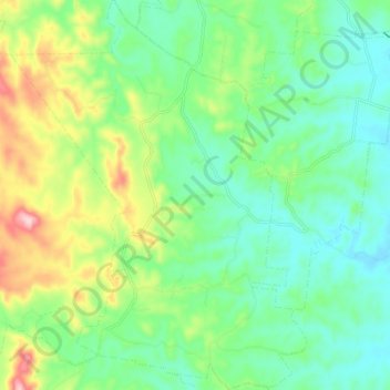
Name: Horse Camp topographic map, elevation, terrain.
Location: Horse Camp, Bundaberg Region, Queensland, 4671, Australia (-25.11657 151.84013 -25.02573 151.91630)
Average elevation: 123 m
Minimum elevation: 49 m
Maximum elevation: 290 m
Make a donation
Gear up for your next adventure:
As an Amazon Associate, this site earns from qualifying purchases at no extra cost to you.
Other topographic maps
Click on a map to view its topography, its elevation and its terrain.
Isis River
Australia > Queensland > Bundaberg Region > South Isis > Isis River
Average elevation: 43 m
Make a donation
Gear up for your next adventure:
As an Amazon Associate, this site earns from qualifying purchases at no extra cost to you.
Make a donation
Gear up for your next adventure:
As an Amazon Associate, this site earns from qualifying purchases at no extra cost to you.