
Make a donation
Gear up for your next adventure:
As an Amazon Associate, this site earns from qualifying purchases at no extra cost to you.
Athol topographic map
Click on the map to display elevation.
Make a donation
Gear up for your next adventure:
As an Amazon Associate, this site earns from qualifying purchases at no extra cost to you.
Athol
According to the United States Census Bureau, the town has a total area of 33.4 square miles (86.5 km2), of which 32.6 square miles (84.4 km2) is land and 0.8 square miles (2.1 km2) (2.46%) is water. The town is drained mostly by the Millers River, which flows through the downtown area from northeast to west, towards the Connecticut River. The Tully River flows into the Millers within town, and many other streams cross the town. Parts of Tully Lake and Lake Rohunta lie within town, as does Lake Ellis and several other small ponds. The soil of Athol is rough and stony, and the terrain is wooded and hilly, with elevations ranging from 500 feet (150 m) above sea level at the edge of the Millers River to 1,282 feet (391 m) at the top of Pratt Hill near the Bearsden Forest. A large portion of the Millers River Wildlife Management Area lies within town, as does a small portion of Petersham State Forest.
Make a donation
Gear up for your next adventure:
As an Amazon Associate, this site earns from qualifying purchases at no extra cost to you.
About this map
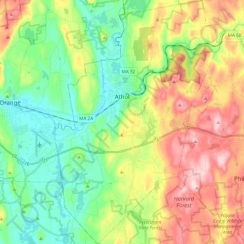
Name: Athol topographic map, elevation, terrain.
Location: Athol, Worcester County, Massachusetts, 01331, United States (42.51344 -72.27666 42.64651 -72.15437)
Average elevation: 251 m
Minimum elevation: 147 m
Maximum elevation: 417 m
Make a donation
Gear up for your next adventure:
As an Amazon Associate, this site earns from qualifying purchases at no extra cost to you.
Other topographic maps
Click on a map to view its topography, its elevation and its terrain.
Make a donation
Gear up for your next adventure:
As an Amazon Associate, this site earns from qualifying purchases at no extra cost to you.
Wachusett Station
United States > Massachusetts > Worcester County > Fitchburg
Average elevation: 229 m
Central (Stanley) Woolen Mill District Park
United States > Massachusetts > Worcester County > Uxbridge
Average elevation: 80 m
Make a donation
Gear up for your next adventure:
As an Amazon Associate, this site earns from qualifying purchases at no extra cost to you.
Crow Hill Ledges
United States > Massachusetts > Worcester County > Westminster
Average elevation: 293 m
Olde English Village
United States > Massachusetts > Worcester County > Gardner
Average elevation: 308 m
Make a donation
Gear up for your next adventure:
As an Amazon Associate, this site earns from qualifying purchases at no extra cost to you.
Vernon Hill
United States > Massachusetts > Worcester County > Worcester > Quinsigamond Village
Average elevation: 162 m
Make a donation
Gear up for your next adventure:
As an Amazon Associate, this site earns from qualifying purchases at no extra cost to you.
Tatnuck
United States > Massachusetts > Worcester County > Worcester > Tatnuck Square
Average elevation: 221 m
Make a donation
Gear up for your next adventure:
As an Amazon Associate, this site earns from qualifying purchases at no extra cost to you.
Institute Park
United States > Massachusetts > Worcester County > Worcester > Belmont Hill
Average elevation: 170 m
Make a donation
Gear up for your next adventure:
As an Amazon Associate, this site earns from qualifying purchases at no extra cost to you.
Hadwen Park
United States > Massachusetts > Worcester County > Worcester > Heard Street
Average elevation: 166 m
Make a donation
Gear up for your next adventure:
As an Amazon Associate, this site earns from qualifying purchases at no extra cost to you.
Thompsons Pond Dam
United States > Massachusetts > Worcester County > Spencer
Average elevation: 278 m
Make a donation
Gear up for your next adventure:
As an Amazon Associate, this site earns from qualifying purchases at no extra cost to you.
Make a donation
Gear up for your next adventure:
As an Amazon Associate, this site earns from qualifying purchases at no extra cost to you.
Northbridge Center
United States > Massachusetts > Worcester County > Northbridge
Average elevation: 124 m
Make a donation
Gear up for your next adventure:
As an Amazon Associate, this site earns from qualifying purchases at no extra cost to you.
Blackburn Village
United States > Massachusetts > Worcester County > Ashburnham
Average elevation: 326 m
Phillipston Four Corners
United States > Massachusetts > Worcester County > Phillipston
Average elevation: 335 m
Make a donation
Gear up for your next adventure:
As an Amazon Associate, this site earns from qualifying purchases at no extra cost to you.
Make a donation
Gear up for your next adventure:
As an Amazon Associate, this site earns from qualifying purchases at no extra cost to you.
Make a donation
Gear up for your next adventure:
As an Amazon Associate, this site earns from qualifying purchases at no extra cost to you.
Make a donation
Gear up for your next adventure:
As an Amazon Associate, this site earns from qualifying purchases at no extra cost to you.
South Charlton Reservoir
United States > Massachusetts > Worcester County > Charlton > South Charlton
Average elevation: 203 m
Make a donation
Gear up for your next adventure:
As an Amazon Associate, this site earns from qualifying purchases at no extra cost to you.
West Upton
United States > Massachusetts > Worcester County > Upton > West Upton
Average elevation: 111 m
Make a donation
Gear up for your next adventure:
As an Amazon Associate, this site earns from qualifying purchases at no extra cost to you.
Jefferson
United States > Massachusetts > Worcester County > Holden > Jefferson
Average elevation: 248 m
Hadwen Arboretum
United States > Massachusetts > Worcester County > Worcester > Main South
Average elevation: 165 m
Martha Templeton Rock
United States > Massachusetts > Worcester County > Southborough
Average elevation: 95 m
Make a donation
Gear up for your next adventure:
As an Amazon Associate, this site earns from qualifying purchases at no extra cost to you.
Make a donation
Gear up for your next adventure:
As an Amazon Associate, this site earns from qualifying purchases at no extra cost to you.
Turkey Hill Shores
United States > Massachusetts > Worcester County > Rutland
Average elevation: 312 m