
Thank you for supporting this site ❤️
Make a donation
Make a donation
Gear up for your next adventure:
As an Amazon Associate, this site earns from qualifying purchases at no extra cost to you.
Stadthagen topographic map
Click on the map to display elevation.
Thank you for supporting this site ❤️
Make a donation
Make a donation
Gear up for your next adventure:
As an Amazon Associate, this site earns from qualifying purchases at no extra cost to you.
About this map
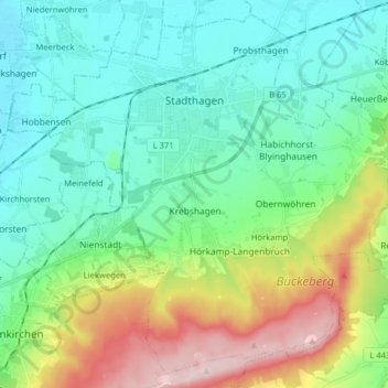
Name: Stadthagen topographic map, elevation, terrain.
Location: Stadthagen, Landkreis Schaumburg, Nedersaksen, 31655, Duitsland (52.25997 9.12815 52.35074 9.28792)
Average elevation: 137 m
Minimum elevation: 49 m
Maximum elevation: 372 m
Thank you for supporting this site ❤️
Make a donation
Make a donation
Gear up for your next adventure:
As an Amazon Associate, this site earns from qualifying purchases at no extra cost to you.
Other topographic maps
Click on a map to view its topography, its elevation and its terrain.
Wiedenbrügge
Duitsland > Nedersaksen > Landkreis Schaumburg > Wölpinghausen > Wiedenbrügge
Average elevation: 60 m