
Make a donation
Gear up for your next adventure:
As an Amazon Associate, this site earns from qualifying purchases at no extra cost to you.
Jüchen topographic map
Click on the map to display elevation.
Make a donation
Gear up for your next adventure:
As an Amazon Associate, this site earns from qualifying purchases at no extra cost to you.
About this map
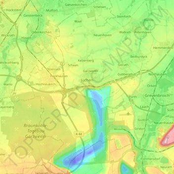
Name: Jüchen topographic map, elevation, terrain.
Average elevation: 71 m
Minimum elevation: -48 m
Maximum elevation: 184 m
Make a donation
Gear up for your next adventure:
As an Amazon Associate, this site earns from qualifying purchases at no extra cost to you.
Other topographic maps
Click on a map to view its topography, its elevation and its terrain.
Stessen
Deutschland > Nordrhein-Westfalen > Rhein-Kreis Neuss > Jüchen > Bedburdyck
Average elevation: 67 m
Make a donation
Gear up for your next adventure:
As an Amazon Associate, this site earns from qualifying purchases at no extra cost to you.
Heckstraße
Deutschland > Nordrhein-Westfalen > Rhein-Kreis Neuss > Grevenbroich > Gilverath
Average elevation: 50 m
Aussichtspunkt Skywalk Jackerath
Deutschland > Nordrhein-Westfalen > Rhein-Kreis Neuss > Jüchen
Average elevation: 85 m
Rubbelrath
Deutschland > Nordrhein-Westfalen > Rhein-Kreis Neuss > Korschenbroich > Liedberg
Average elevation: 58 m
Am Böhnerfeld
Deutschland > Nordrhein-Westfalen > Rhein-Kreis Neuss > Grevenbroich
Average elevation: 55 m
Make a donation
Gear up for your next adventure:
As an Amazon Associate, this site earns from qualifying purchases at no extra cost to you.
Am Neuhauser Weg
Deutschland > Nordrhein-Westfalen > Rhein-Kreis Neuss > Grevenbroich > Neukirchen > Gut Neuhaus
Average elevation: 52 m
Ramrath
Deutschland > Nordrhein-Westfalen > Rhein-Kreis Neuss > Rommerskirchen
Ramrath befindet sich auf einer Höhe von 54 NN und liegt damit etwas niedriger als die Nachbarorte. Südöstlich von Ramrath liegt Hoeningen. Westlich schließt sich Villau an die Ortschaft Ramrath an. Nordwestlich von Ramrath verläuft der Strategische Bahndamm.
Average elevation: 58 m
Make a donation
Gear up for your next adventure:
As an Amazon Associate, this site earns from qualifying purchases at no extra cost to you.
Korschenbroich
Deutschland > Nordrhein-Westfalen > Rhein-Kreis Neuss > Korschenbroich > Korschenbroich
Average elevation: 46 m
Schlich
Deutschland > Nordrhein-Westfalen > Rhein-Kreis Neuss > Korschenbroich > Schlich
Average elevation: 50 m
Make a donation
Gear up for your next adventure:
As an Amazon Associate, this site earns from qualifying purchases at no extra cost to you.
Broicherseite
Deutschland > Nordrhein-Westfalen > Rhein-Kreis Neuss > Kaarst > Broicherseite
Average elevation: 40 m
Herzbroich
Deutschland > Nordrhein-Westfalen > Rhein-Kreis Neuss > Korschenbroich
Average elevation: 42 m
Hoppers
Deutschland > Nordrhein-Westfalen > Rhein-Kreis Neuss > Jüchen > Kelzenberg
Average elevation: 67 m
Make a donation
Gear up for your next adventure:
As an Amazon Associate, this site earns from qualifying purchases at no extra cost to you.
Lanzerath
Deutschland > Nordrhein-Westfalen > Rhein-Kreis Neuss > Neuss > Grefrath
Average elevation: 48 m