
Keele topographic map
Click on the map to display elevation.
About this map
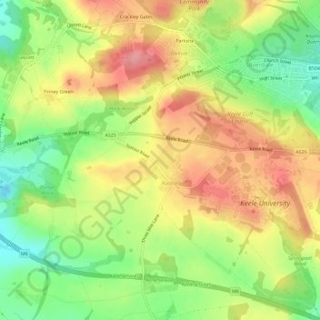
Name: Keele topographic map, elevation, terrain.
Average elevation: 166 m
Minimum elevation: 113 m
Maximum elevation: 217 m
Other topographic maps
Click on a map to view its topography, its elevation and its terrain.
College Gardens
United Kingdom > England > Staffordshire > Newcastle-under-Lyme > Madeley
Average elevation: 123 m
Wain Lea
United Kingdom > England > Staffordshire > Newcastle-under-Lyme > Harriseahead
Average elevation: 207 m
Apedale
United Kingdom > England > Staffordshire > Newcastle-under-Lyme > Chesterton
Average elevation: 168 m
Bignall End
United Kingdom > England > Staffordshire > Newcastle-under-Lyme > Audley
Average elevation: 150 m
Wood Lane
United Kingdom > England > Staffordshire > Newcastle-under-Lyme > Bignall Hill
Average elevation: 168 m
Whitmore Heath
United Kingdom > England > Staffordshire > Newcastle-under-Lyme > Whitmore
Average elevation: 141 m
Birks Wood
United Kingdom > England > Staffordshire > Newcastle-under-Lyme > Shraleybrook
Average elevation: 109 m
Burgess Brook
United Kingdom > England > Staffordshire > Newcastle-under-Lyme
Average elevation: 149 m
Talke Pits
United Kingdom > England > Staffordshire > Newcastle-under-Lyme > Talke
Average elevation: 179 m
Blore
United Kingdom > England > Staffordshire > Newcastle-under-Lyme > Loggerheads
Average elevation: 137 m
Ashley Dale
United Kingdom > England > Staffordshire > Newcastle-under-Lyme > Loggerheads
Average elevation: 172 m
Barhill
United Kingdom > England > Staffordshire > Newcastle-under-Lyme > Madeley
Average elevation: 122 m
The Moss
United Kingdom > England > Staffordshire > Newcastle-under-Lyme > Madeley
Average elevation: 122 m
Chapel Chorlton
United Kingdom > England > Staffordshire > Newcastle-under-Lyme
Average elevation: 133 m
Red Bull
United Kingdom > England > Staffordshire > Newcastle-under-Lyme > Loggerheads
Average elevation: 110 m
Dunkirk
United Kingdom > England > Staffordshire > Newcastle-under-Lyme > Talke > Dunkirk
Average elevation: 149 m
Madeley Heath
United Kingdom > England > Staffordshire > Newcastle-under-Lyme
Average elevation: 139 m