
Make a donation
Gear up for your next adventure:
As an Amazon Associate, this site earns from qualifying purchases at no extra cost to you.
Gundlupet topographic map
Click on the map to display elevation.
Make a donation
Gear up for your next adventure:
As an Amazon Associate, this site earns from qualifying purchases at no extra cost to you.
Gundlupet
Gundlupet is located at 11°48′N 76°41′E / 11.8°N 76.68°E / 11.8; 76.68. It has an average elevation of 816 metres (2,677 feet).
Make a donation
Gear up for your next adventure:
As an Amazon Associate, this site earns from qualifying purchases at no extra cost to you.
About this map
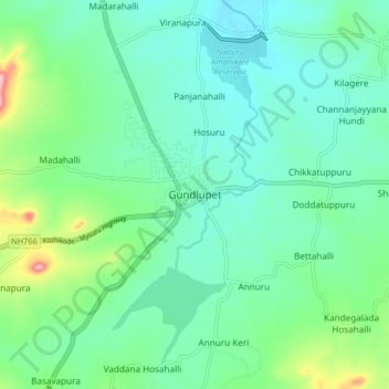
Name: Gundlupet topographic map, elevation, terrain.
Average elevation: 807 m
Minimum elevation: 763 m
Maximum elevation: 956 m
Make a donation
Gear up for your next adventure:
As an Amazon Associate, this site earns from qualifying purchases at no extra cost to you.
Other topographic maps
Click on a map to view its topography, its elevation and its terrain.
Bandipur National Park
India > Karnataka > Gundlupet taluk
Bandipur National Park is located between 75° 12’ 17" E to 76° 51’ 32" E and 11° 35’ 34" N to 11° 57’ 02" N where the Deccan Plateau meets the Western Ghats, and the altitude of the park ranges from 680 m (2,230 ft) to 1,454 m (4,770 ft). As a result, the park has a variety of biomes including dry…
Average elevation: 860 m