
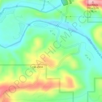
Beavers Bend State Park topographic map
Interactive map
Click on the map to display elevation.
About this map
Name: Beavers Bend State Park topographic map, elevation, terrain.
Average elevation: 178 m
Minimum elevation: 123 m
Maximum elevation: 288 m
Other topographic maps
Click on a map to view its topography, its elevation and its terrain.
Broken Bow
United States > Oklahoma > McCurtain County
Broken Bow, McCurtain County, Oklahoma, United States
Average elevation: 155 m
Hochatown
United States > Oklahoma > McCurtain County
Hochatown, McCurtain County, Oklahoma, United States
Average elevation: 220 m
Hochatown
United States > Oklahoma > McCurtain County
Hochatown, McCurtain County, Oklahoma, United States
Average elevation: 218 m
Watson
United States > Oklahoma > McCurtain County
Watson, McCurtain County, Oklahoma, 74963, United States
Average elevation: 268 m
Garvin
United States > Oklahoma > McCurtain County > Garvin
Garvin, McCurtain County, Oklahoma, United States
Average elevation: 144 m
Eagletown
United States > Oklahoma > McCurtain County > Eagletown
Eagletown, McCurtain County, Oklahoma, 74734, United States
Average elevation: 120 m
Pickens
United States > Oklahoma > McCurtain County > Pickens
Pickens, McCurtain County, Oklahoma, United States
Average elevation: 261 m
Broken Bow Lake
United States > Oklahoma > McCurtain County
Broken Bow Lake, McCurtain County, Oklahoma, United States
Average elevation: 158 m
Idabel
United States > Oklahoma > McCurtain County
Idabel, McCurtain County, Oklahoma, United States
Average elevation: 132 m