
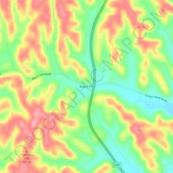
Beech Hill topographic map
Interactive map
Click on the map to display elevation.
About this map
Name: Beech Hill topographic map, elevation, terrain.
Average elevation: 269 m
Minimum elevation: 213 m
Maximum elevation: 323 m
Other topographic maps
Click on a map to view its topography, its elevation and its terrain.
Frankewing
United States > Tennessee > Giles County
Frankewing, Giles County, Middle Tennessee, Tennessee, 38459, United States
Average elevation: 239 m
Waco
United States > Tennessee > Giles County
Waco, Giles County, Middle Tennessee, Tennessee, 38472, United States
Average elevation: 247 m
Weakley
United States > Tennessee > Giles County
Weakley, Giles County, Middle Tennessee, Tennessee, United States
Average elevation: 255 m
Liberty Hill
United States > Tennessee > Giles County
Liberty Hill, Giles County, Middle Tennessee, Tennessee, United States
Average elevation: 305 m
Five Points
United States > Tennessee > Giles County
Five Points, Giles County, Middle Tennessee, Tennessee, United States
Average elevation: 250 m
Berea
United States > Tennessee > Giles County
Berea, Giles County, Middle Tennessee, Tennessee, United States
Average elevation: 284 m
Aspen Hill
United States > Tennessee > Giles County
Aspen Hill, Giles County, Middle Tennessee, Tennessee, United States
Average elevation: 204 m
Prospect
United States > Tennessee > Giles County
Prospect, Giles County, Middle Tennessee, Tennessee, 38477, United States
Average elevation: 212 m
Elkton
United States > Tennessee > Giles County
Elkton, Giles County, Middle Tennessee, Tennessee, United States
Average elevation: 209 m
Olivet
United States > Tennessee > Giles County
Olivet, Giles County, Middle Tennessee, Tennessee, United States
Average elevation: 239 m
Goodspring
United States > Tennessee > Giles County
Goodspring, Giles County, Middle Tennessee, Tennessee, United States
Average elevation: 280 m
Campbellsville
United States > Tennessee > Giles County
Campbellsville, Giles County, Middle Tennessee, Tennessee, United States
Average elevation: 259 m
Aymett Town
United States > Tennessee > Giles County
Aymett Town, Giles County, Middle Tennessee, Tennessee, United States
Average elevation: 238 m
Minor Hill
United States > Tennessee > Giles County
Minor Hill, Giles County, Middle Tennessee, Tennessee, United States
Average elevation: 243 m
Anthony Hill
United States > Tennessee > Giles County
Anthony Hill, Giles County, Tennessee, United States
Average elevation: 288 m
Pulaski
United States > Tennessee > Giles County
Pulaski, Giles County, Middle Tennessee, Tennessee, 38478, United States
Average elevation: 233 m
Friendship
United States > Tennessee > Giles County > Friendship
Friendship, Giles County, Tennessee, United States
Average elevation: 281 m
Pulaski
United States > Tennessee > Giles County > Pulaski
Pulaski, Giles County, Tennessee, 38478, United States
Average elevation: 238 m
Ardmore
United States > Tennessee > Giles County > Ardmore
Ardmore, Giles County, Tennessee, United States
Average elevation: 253 m
Lynnville
United States > Tennessee > Giles County
Lynnville, Giles County, Middle Tennessee, Tennessee, United States
Average elevation: 246 m
Ardmore
United States > Tennessee > Giles County
Ardmore, Giles County, Middle Tennessee, Tennessee, United States
Average elevation: 271 m