
Make a donation
Gear up for your next adventure:
As an Amazon Associate, this site earns from qualifying purchases at no extra cost to you.
Tatra Mountains topographic map
Click on the map to display elevation.
Make a donation
Gear up for your next adventure:
As an Amazon Associate, this site earns from qualifying purchases at no extra cost to you.
Tatra Mountains
The Tatras lie in the temperate zone of Central Europe. They are an important barrier to the movements of air masses. Their mountainous topography causes one of the most diverse climates in that region.
Make a donation
Gear up for your next adventure:
As an Amazon Associate, this site earns from qualifying purchases at no extra cost to you.
About this map
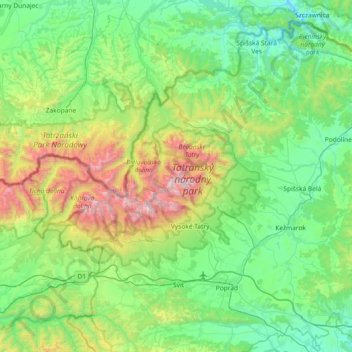
Name: Tatra Mountains topographic map, elevation, terrain.
Location: Tatra Mountains, Region of Prešov, Eastern Slovakia, Slovakia (49.13169 19.58516 49.28360 20.32012)
Average elevation: 1,001 m
Minimum elevation: 508 m
Maximum elevation: 2,611 m
Make a donation
Gear up for your next adventure:
As an Amazon Associate, this site earns from qualifying purchases at no extra cost to you.
Other topographic maps
Click on a map to view its topography, its elevation and its terrain.
Rysy
Slovakia > Region of Prešov > District of Poprad
It is possible to reach the peak from the Slovak side, starting at Štrbské pleso and passing Chata pod Rysmi, a mountain chalet at an altitude of 2,250 m (7,380 ft). Between November 1 and June 15, the trail and chalet on the Slovak side are closed.
Average elevation: 2,005 m
Gerlachovský štít
Slovakia > Region of Prešov > District of Poprad
Gerlachovský štít (Slovak pronunciation, translated into English as Gerlachov Peak, German: Gerlsdorfer Spitze, Hungarian: Gerlachfalvi-csúcs), informally referred to as Gerlach, is the highest peak in the High Tatras, in Slovakia, and in the Carpathian Mountains. Its elevation is usually listed at 2654.4…
Average elevation: 2,103 m
Medený vodopád
Slovakia > Region of Prešov > District of Poprad > Vysoké Tatry
Average elevation: 2,004 m
Make a donation
Gear up for your next adventure:
As an Amazon Associate, this site earns from qualifying purchases at no extra cost to you.
Kriváň
Slovakia > Region of Prešov > District of Poprad > Vysoké Tatry
The relative elevations of the two mountains were determined by the English natural historian Robert Townson, who ascended both peaks in August 1793 and also made an early recorded comment on Kriváň's aesthetic appeal.
Average elevation: 1,913 m
Make a donation
Gear up for your next adventure:
As an Amazon Associate, this site earns from qualifying purchases at no extra cost to you.
Nad lomom
Slovakia > Region of Prešov > District of Prešov > Drienovská Nová Ves
Average elevation: 294 m
Kriváň
Slovakia > Region of Prešov > District of Poprad
The relative elevations of the two mountains were determined by the English natural historian Robert Townson, who ascended both peaks in August 1793 and also made an early recorded comment on Kriváň's aesthetic appeal.
Average elevation: 1,913 m
Make a donation
Gear up for your next adventure:
As an Amazon Associate, this site earns from qualifying purchases at no extra cost to you.
Vodná nádrž Veľká Domaša
Slovakia > Region of Prešov > District of Vranov nad Topľou > Nová Kelča
Domaša is spread over the area of the districts of Vranov nad Topľou and Stropkov at the average altitude of 156 m (512 ft). With an agreeable climate and an average temperature of 23 °C (73 °F) it guarantees pleasant swimming in clean water from June to mid-September.
Average elevation: 268 m
Make a donation
Gear up for your next adventure:
As an Amazon Associate, this site earns from qualifying purchases at no extra cost to you.
Havran
Slovakia > Region of Prešov > District of Poprad > Tatranská Javorina
Average elevation: 1,624 m
Druhý Mních / Zadni Mnich
Slovakia > Region of Prešov > District of Poprad > Vysoké Tatry
Average elevation: 1,921 m
Rysy
Slovakia > Region of Prešov > District of Poprad
It is possible to reach the peak from the Slovak side, starting at Štrbské pleso and passing Chata pod Rysmi, a mountain chalet at an altitude of 2,250 m (7,380 ft). Between November 1 and June 15, the trail and chalet on the Slovak side are closed.
Average elevation: 2,005 m
Make a donation
Gear up for your next adventure:
As an Amazon Associate, this site earns from qualifying purchases at no extra cost to you.
Poprad
Slovakia > Region of Prešov > District of Poprad > Poprad > Poprad
International Poprad–Tatry Airport from 1938, is an airport with the highest elevations in Central Europe. It also offers scheduled flights to London.
Average elevation: 699 m
Hermanovce nad Topľou
Slovakia > Region of Prešov > District of Vranov nad Topľou > Hermanovce nad Topľou > Hermanovce nad Topľou
Average elevation: 338 m