
Thank you for supporting this site ❤️
Make a donation
Make a donation
Gear up for your next adventure:
As an Amazon Associate, this site earns from qualifying purchases at no extra cost to you.
Regenstauf topographic map
Click on the map to display elevation.
Thank you for supporting this site ❤️
Make a donation
Make a donation
Gear up for your next adventure:
As an Amazon Associate, this site earns from qualifying purchases at no extra cost to you.
About this map
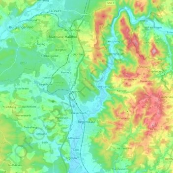
Name: Regenstauf topographic map, elevation, terrain.
Location: Regenstauf, Landkreis Regensburg, Bavaria, 93128, Germany (49.08654 12.00369 49.22328 12.23586)
Average elevation: 411 m
Minimum elevation: 331 m
Maximum elevation: 605 m
Thank you for supporting this site ❤️
Make a donation
Make a donation
Gear up for your next adventure:
As an Amazon Associate, this site earns from qualifying purchases at no extra cost to you.