
Pridnestrovie topographic map
Interactive map
Click on the map to display elevation.
About this map
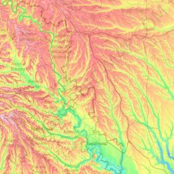
Name: Pridnestrovie topographic map, elevation, terrain.
Location: Pridnestrovie, Moldova (46.54674 28.49147 48.18245 29.97942)
Average elevation: 140 m
Minimum elevation: -8 m
Maximum elevation: 392 m
Other topographic maps
Click on a map to view its topography, its elevation and its terrain.
посёлок Геологов
Moldova > Transnistria > Dubăsari town council
посёлок Геологов, Dubăsari town council, Dubasari District, Administrative-Territorial Units from the Left Bank of the Dniester, Transnistria, 4520, Moldova
Average elevation: 31 m