
Thank you for supporting this site ❤️
Make a donation
Make a donation
Gear up for your next adventure:
As an Amazon Associate, this site earns from qualifying purchases at no extra cost to you.
Angern topographic map
Click on the map to display elevation.
Thank you for supporting this site ❤️
Make a donation
Make a donation
Gear up for your next adventure:
As an Amazon Associate, this site earns from qualifying purchases at no extra cost to you.
About this map
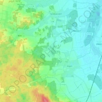
Name: Angern topographic map, elevation, terrain.
Location: Angern, Elbe-Heide, Börde, Sachsen-Anhalt, Deutschland (52.33361 11.66962 52.40288 11.79021)
Average elevation: 57 m
Minimum elevation: 37 m
Maximum elevation: 110 m
Thank you for supporting this site ❤️
Make a donation
Make a donation
Gear up for your next adventure:
As an Amazon Associate, this site earns from qualifying purchases at no extra cost to you.