
Make a donation
Gear up for your next adventure:
As an Amazon Associate, this site earns from qualifying purchases at no extra cost to you.
Fischingen topographic map
Click on the map to display elevation.
Make a donation
Gear up for your next adventure:
As an Amazon Associate, this site earns from qualifying purchases at no extra cost to you.
About this map
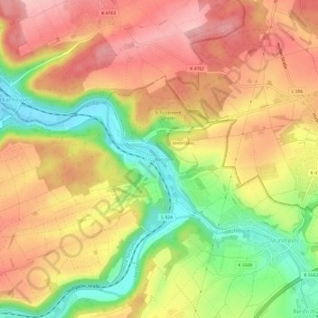
Name: Fischingen topographic map, elevation, terrain.
Average elevation: 493 m
Minimum elevation: 403 m
Maximum elevation: 562 m
Make a donation
Gear up for your next adventure:
As an Amazon Associate, this site earns from qualifying purchases at no extra cost to you.
Other topographic maps
Click on a map to view its topography, its elevation and its terrain.
Bergfelden
Deutschland > Baden-Württemberg > Landkreis Rottweil > Sulz am Neckar
Bergfelden liegt knapp fünf Kilometer östlich der Stadt Sulz am Neckar, im oberen Mühlbachtal am Fuße des Dickebergs. Der Ort liegt auf einer Höhe von 490 m ü. NN und hat ca. 1700 Einwohner (Stand 2015).
Average elevation: 528 m
Holzhausen
Deutschland > Baden-Württemberg > Landkreis Rottweil > Sulz am Neckar
Average elevation: 501 m
Make a donation
Gear up for your next adventure:
As an Amazon Associate, this site earns from qualifying purchases at no extra cost to you.
Dürrenmettstetten
Deutschland > Baden-Württemberg > Landkreis Rottweil > Sulz am Neckar
Average elevation: 627 m