
Thank you for supporting this site ❤️
Make a donation
Make a donation
Gear up for your next adventure:
As an Amazon Associate, this site earns from qualifying purchases at no extra cost to you.
Troviscal topographic map
Click on the map to display elevation.
Thank you for supporting this site ❤️
Make a donation
Make a donation
Gear up for your next adventure:
As an Amazon Associate, this site earns from qualifying purchases at no extra cost to you.
About this map
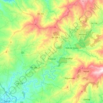
Name: Troviscal topographic map, elevation, terrain.
Location: Troviscal, Sertã, Castelo Branco, Portugal (39.83484 -8.09708 39.90952 -7.91586)
Average elevation: 544 m
Minimum elevation: 225 m
Maximum elevation: 1,071 m
Thank you for supporting this site ❤️
Make a donation
Make a donation
Gear up for your next adventure:
As an Amazon Associate, this site earns from qualifying purchases at no extra cost to you.