
Make a donation
Gear up for your next adventure:
As an Amazon Associate, this site earns from qualifying purchases at no extra cost to you.
Angerstein topographic map
Click on the map to display elevation.
Make a donation
Gear up for your next adventure:
As an Amazon Associate, this site earns from qualifying purchases at no extra cost to you.
About this map
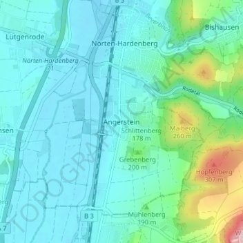
Name: Angerstein topographic map, elevation, terrain.
Average elevation: 168 m
Minimum elevation: 126 m
Maximum elevation: 371 m
Make a donation
Gear up for your next adventure:
As an Amazon Associate, this site earns from qualifying purchases at no extra cost to you.
Other topographic maps
Click on a map to view its topography, its elevation and its terrain.
Einbeck
Germany > Lower Saxony > Landkreis Northeim
In the Early Middle Ages a number of villages existed along the river Ilme in the middle Leine valley before Einbeck was founded. On January 1, 1158 Einbeck was first mentioned in a deed of Friedrich Barbarossa, which mentioned … in loco qui Einbike vocatur …. and related to a transfer of an estate in the…
Average elevation: 198 m
Make a donation
Gear up for your next adventure:
As an Amazon Associate, this site earns from qualifying purchases at no extra cost to you.