
Make a donation
Gear up for your next adventure:
As an Amazon Associate, this site earns from qualifying purchases at no extra cost to you.
Cisarua topographic map
Click on the map to display elevation.
Make a donation
Gear up for your next adventure:
As an Amazon Associate, this site earns from qualifying purchases at no extra cost to you.
Cisarua
The district is known for its mild climate, tea fields, and extensive views, being located in a rather high altitude. Near the district is a mountain pass known for its villas, hostels, as well as a well-known "heritage" hotel known as the "Puncak Pass", built in 1928.
Make a donation
Gear up for your next adventure:
As an Amazon Associate, this site earns from qualifying purchases at no extra cost to you.
About this map
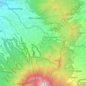
Name: Cisarua topographic map, elevation, terrain.
Location: Cisarua, Bogor, West Java, Java, 16750, Indonesia (-6.77032 106.89486 -6.64657 107.00683)
Average elevation: 1,310 m
Minimum elevation: 592 m
Maximum elevation: 2,999 m
Make a donation
Gear up for your next adventure:
As an Amazon Associate, this site earns from qualifying purchases at no extra cost to you.