
Make a donation
Gear up for your next adventure:
As an Amazon Associate, this site earns from qualifying purchases at no extra cost to you.
Leeds topographic map
Click on the map to display elevation.
Make a donation
Gear up for your next adventure:
As an Amazon Associate, this site earns from qualifying purchases at no extra cost to you.
About this map
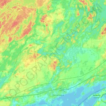
Name: Leeds topographic map, elevation, terrain.
Average elevation: 104 m
Minimum elevation: 73 m
Maximum elevation: 185 m
Make a donation
Gear up for your next adventure:
As an Amazon Associate, this site earns from qualifying purchases at no extra cost to you.
Other topographic maps
Click on a map to view its topography, its elevation and its terrain.
Seeleys Bay
Canada > Ontario > Leeds and Grenville Counties > Leeds and the Thousand Islands > Seeley's Bay
Average elevation: 105 m
Lansdowne
Canada > Ontario > Leeds and Grenville Counties > Leeds and the Thousand Islands
Average elevation: 101 m
Waterton
Canada > Ontario > Leeds and Grenville Counties > Leeds and the Thousand Islands > Waterton
Average elevation: 97 m
Seeley's Bay
Canada > Ontario > Leeds and Grenville Counties > Leeds and the Thousand Islands
Average elevation: 106 m
Make a donation
Gear up for your next adventure:
As an Amazon Associate, this site earns from qualifying purchases at no extra cost to you.
Codfish Island
Canada > Ontario > Leeds and Grenville Counties > Leeds and the Thousand Islands
Average elevation: 79 m
Why Island
Canada > Ontario > Leeds and Grenville Counties > Leeds and the Thousand Islands
Average elevation: 92 m
Seeleys Bay
Canada > Ontario > Leeds and Grenville Counties > Leeds and the Thousand Islands > Seeley's Bay
Average elevation: 105 m
Outlet
Canada > Ontario > Leeds and Grenville Counties > Leeds and the Thousand Islands
Average elevation: 97 m
Make a donation
Gear up for your next adventure:
As an Amazon Associate, this site earns from qualifying purchases at no extra cost to you.