
Granges-près-Marnand topographic map
Interactive map
Click on the map to display elevation.
About this map
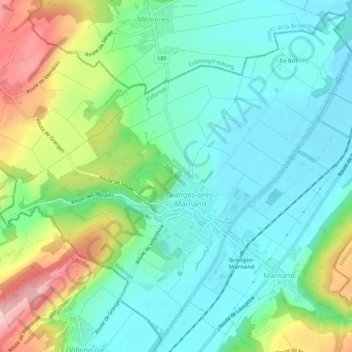
Name: Granges-près-Marnand topographic map, elevation, terrain.
Average elevation: 517 m
Minimum elevation: 457 m
Maximum elevation: 660 m
Other topographic maps
Click on a map to view its topography, its elevation and its terrain.
Combremont-le-Petit
Suisse > Vaud > District de la Broye-Vully > Valbroye
Combremont-le-Petit, Valbroye, District de la Broye-Vully, Vaud, 1536, Suisse
Average elevation: 676 m
Cerniaz
Suisse > Vaud > District de la Broye-Vully > Valbroye
Cerniaz, Valbroye, District de la Broye-Vully, Vaud, 1525, Suisse
Average elevation: 658 m