
Make a donation
Gear up for your next adventure:
As an Amazon Associate, this site earns from qualifying purchases at no extra cost to you.
Donsbrüggen topographic map
Click on the map to display elevation.
Make a donation
Gear up for your next adventure:
As an Amazon Associate, this site earns from qualifying purchases at no extra cost to you.
Donsbrüggen
In 1824 werd de achthoekige houten torenmolen van Donsbrüggen met een hoogte van 20 meter in werking gesteld. Rondom de molen ligt een aarden wal. De molen heeft bilau- of ventiwieken met een diameter van 21 meter. In 1890 werd een stoommachine in de molen geplaatst. Deze werd na de Tweede Wereldoorlog buiten werking gesteld.
Make a donation
Gear up for your next adventure:
As an Amazon Associate, this site earns from qualifying purchases at no extra cost to you.
About this map
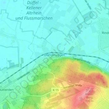
Name: Donsbrüggen topographic map, elevation, terrain.
Average elevation: 29 m
Minimum elevation: 6 m
Maximum elevation: 101 m
Make a donation
Gear up for your next adventure:
As an Amazon Associate, this site earns from qualifying purchases at no extra cost to you.
Other topographic maps
Click on a map to view its topography, its elevation and its terrain.