
Make a donation
Gear up for your next adventure:
As an Amazon Associate, this site earns from qualifying purchases at no extra cost to you.
Erie County topographic map
Click on the map to display elevation.
Make a donation
Gear up for your next adventure:
As an Amazon Associate, this site earns from qualifying purchases at no extra cost to you.
Erie County
Most of the county has a warm-summer humid continental climate (Dfb), except at lower elevations near enough to the lake, where a hot-summer humid continental climate (Dfa) exists. Average monthly temperatures in downtown Erie range from 26.4 °F in January to 70.8 °F in July, while in Corry they range from 23.8 °F in January to 68.2 °F in July. The hardiness zone in most of Erie County by area is 6a. It has warmed to 7a along the Lake and the area between the shore and a line a little south of Interstate 90 is 6b. [1]
Make a donation
Gear up for your next adventure:
As an Amazon Associate, this site earns from qualifying purchases at no extra cost to you.
About this map
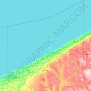
Name: Erie County topographic map, elevation, terrain.
Location: Erie County, Pennsylvania, United States (41.84897 -80.52109 42.51613 -79.60993)
Average elevation: 248 m
Minimum elevation: 170 m
Maximum elevation: 572 m
Make a donation
Gear up for your next adventure:
As an Amazon Associate, this site earns from qualifying purchases at no extra cost to you.
Other topographic maps
Click on a map to view its topography, its elevation and its terrain.
East Texas
United States > Pennsylvania > Lehigh County > Lower Macungie Township
Average elevation: 126 m
Make a donation
Gear up for your next adventure:
As an Amazon Associate, this site earns from qualifying purchases at no extra cost to you.
Valley Forge
United States > Pennsylvania > Chester County > Schuylkill Township
Average elevation: 78 m
Stahlstown
United States > Pennsylvania > Westmoreland County > Cook Township
Average elevation: 514 m
Acme
United States > Pennsylvania > Westmoreland County > Mount Pleasant Township
Average elevation: 585 m
Cross Fork
United States > Pennsylvania > Potter County > Stewardson Township
Average elevation: 467 m
Make a donation
Gear up for your next adventure:
As an Amazon Associate, this site earns from qualifying purchases at no extra cost to you.
Dingmans Ferry
United States > Pennsylvania > Pike County > Delaware Township
Average elevation: 192 m
Blue Mountain
United States > Pennsylvania > Monroe County > Eldred Township
The ridge of Blue Mountain runs for 150 miles (240 km) through Pennsylvania, reaching an elevation of 2,270 feet (690 m) above sea level just north of the Pennsylvania Turnpike, near the borough of Newburg. Most of the ridgecrest, however, only reaches between 1,400 and 1,700 feet (430 and 520 m) in elevation.…
Average elevation: 242 m
Make a donation
Gear up for your next adventure:
As an Amazon Associate, this site earns from qualifying purchases at no extra cost to you.
Champion
United States > Pennsylvania > Allegheny County > North Fayette Township
Average elevation: 360 m
Lake Keystone
United States > Pennsylvania > Armstrong County > Plumcreek Township
Keystone Lake (also known as Keystone Reservoir and Plum Creek Reservoir) is a reservoir in Armstrong County in the U.S. state of Pennsylvania. The elevation of Keystone Lake is 1,076 feet (328 m) above sea level.
Average elevation: 357 m
Make a donation
Gear up for your next adventure:
As an Amazon Associate, this site earns from qualifying purchases at no extra cost to you.
Middlebury Center
United States > Pennsylvania > Tioga County > Middlebury Township
Average elevation: 462 m
Woxall
United States > Pennsylvania > Montgomery County > Upper Salford Township
Average elevation: 98 m
Donegal Lake
United States > Pennsylvania > Westmoreland County > Donegal Township
Average elevation: 493 m
Make a donation
Gear up for your next adventure:
As an Amazon Associate, this site earns from qualifying purchases at no extra cost to you.
Centreville
United States > Pennsylvania > Lehigh County > Lower Macungie Township
Average elevation: 144 m
Bass Lake
United States > Pennsylvania > York County > Newberry Township > Valley Green
Average elevation: 143 m
Croydon Heights
United States > Pennsylvania > Bucks County > Bristol Township > Croydon
Average elevation: 10 m
Make a donation
Gear up for your next adventure:
As an Amazon Associate, this site earns from qualifying purchases at no extra cost to you.
Fitzwatertown
United States > Pennsylvania > Montgomery County > Upper Dublin Township
Average elevation: 86 m
Starview
United States > Pennsylvania > York County > East Manchester Township
Average elevation: 155 m
North Towanda
United States > Pennsylvania > Bradford County > North Towanda Township
Average elevation: 286 m
Make a donation
Gear up for your next adventure:
As an Amazon Associate, this site earns from qualifying purchases at no extra cost to you.
Albrightsville
United States > Pennsylvania > Carbon County > Kidder Township
Average elevation: 498 m
Make a donation
Gear up for your next adventure:
As an Amazon Associate, this site earns from qualifying purchases at no extra cost to you.
Brackney
United States > Pennsylvania > Susquehanna County > Silver Lake Township
Average elevation: 491 m
Wimmers
United States > Pennsylvania > Lackawanna County > Jefferson Township > Mount Cobb
Average elevation: 495 m
Make a donation
Gear up for your next adventure:
As an Amazon Associate, this site earns from qualifying purchases at no extra cost to you.
Make a donation
Gear up for your next adventure:
As an Amazon Associate, this site earns from qualifying purchases at no extra cost to you.
Make a donation
Gear up for your next adventure:
As an Amazon Associate, this site earns from qualifying purchases at no extra cost to you.
Freemont
United States > Pennsylvania > Chester County > West Nottingham Township
Average elevation: 115 m
Sturgeon
United States > Pennsylvania > Allegheny County > North Fayette Township
Average elevation: 334 m
Glade Mills
United States > Pennsylvania > Butler County > Middlesex Township
Average elevation: 359 m
Knickerbocker
United States > Pennsylvania > Chester County > Willistown Township
Average elevation: 127 m
Make a donation
Gear up for your next adventure:
As an Amazon Associate, this site earns from qualifying purchases at no extra cost to you.
Carlisle Springs
United States > Pennsylvania > Cumberland County > Middlesex Township
Average elevation: 182 m
Vance
United States > Pennsylvania > Washington County > South Strabane Township
Average elevation: 371 m
Sagamore Estates
United States > Pennsylvania > Pike County > Shohola Township
Average elevation: 412 m
Make a donation
Gear up for your next adventure:
As an Amazon Associate, this site earns from qualifying purchases at no extra cost to you.
Evansburg State Park
United States > Pennsylvania > Montgomery County > Worcester Township > Cedars
Average elevation: 70 m
Ithan
United States > Pennsylvania > Delaware County > Radnor Township > Saint Davids
Average elevation: 116 m
Drumore Center
United States > Pennsylvania > Lancaster County > Drumore Township
Average elevation: 175 m
Make a donation
Gear up for your next adventure:
As an Amazon Associate, this site earns from qualifying purchases at no extra cost to you.
Orefield
United States > Pennsylvania > Lehigh County > North Whitehall Township
Average elevation: 141 m
Make a donation
Gear up for your next adventure:
As an Amazon Associate, this site earns from qualifying purchases at no extra cost to you.
Mount Nebo Park
United States > Pennsylvania > Monroe County > East Stroudsburg > Twin Falls
Average elevation: 185 m
Cowden
United States > Pennsylvania > Washington County > Cecil Township > Cecil
Average elevation: 346 m
Make a donation
Gear up for your next adventure:
As an Amazon Associate, this site earns from qualifying purchases at no extra cost to you.
Keown Station
United States > Pennsylvania > Allegheny County > Ross Township
Average elevation: 344 m
Make a donation
Gear up for your next adventure:
As an Amazon Associate, this site earns from qualifying purchases at no extra cost to you.
Make a donation
Gear up for your next adventure:
As an Amazon Associate, this site earns from qualifying purchases at no extra cost to you.
New Enterprise
United States > Pennsylvania > Bedford County > South Woodbury Township
Average elevation: 397 m
Make a donation
Gear up for your next adventure:
As an Amazon Associate, this site earns from qualifying purchases at no extra cost to you.
Blue Knob
United States > Pennsylvania > Bedford County > Pavia Township
Blue Knob (elevation 3,146 feet (959 m)) is a summit in the eastern United States with a broad dome that is the northernmost 3,000-footer in the Allegheny Mountains. It is the highest point in Bedford County, Pennsylvania.
Average elevation: 792 m
Sinnemahoning
United States > Pennsylvania > Cameron County > Gibson Township
Average elevation: 406 m
Saint Benedict
United States > Pennsylvania > Cambria County > West Carroll Township
Average elevation: 582 m
Make a donation
Gear up for your next adventure:
As an Amazon Associate, this site earns from qualifying purchases at no extra cost to you.
Fort Hunter
United States > Pennsylvania > Dauphin County > Middle Paxton Township
Average elevation: 149 m
Green Village
United States > Pennsylvania > Franklin County > Greene Township
Average elevation: 207 m
Make a donation
Gear up for your next adventure:
As an Amazon Associate, this site earns from qualifying purchases at no extra cost to you.
Normalville
United States > Pennsylvania > Fayette County > Springfield Township
Average elevation: 486 m
Arnold City
United States > Pennsylvania > Fayette County > Washington Township
Average elevation: 303 m
Three Tuns
United States > Pennsylvania > Montgomery County > Upper Dublin Township > Maple Glen
Average elevation: 101 m
Make a donation
Gear up for your next adventure:
As an Amazon Associate, this site earns from qualifying purchases at no extra cost to you.
Hidden Valley
United States > Pennsylvania > Montgomery County > Upper Merion Township
Average elevation: 47 m
Strafford
United States > Pennsylvania > Chester County > Tredyffrin Township
Average elevation: 133 m
Make a donation
Gear up for your next adventure:
As an Amazon Associate, this site earns from qualifying purchases at no extra cost to you.
West Pittsburg
United States > Pennsylvania > Lawrence County > Taylor Township
Average elevation: 279 m
Robinson
United States > Pennsylvania > Indiana County > West Wheatfield Township
Average elevation: 397 m
Make a donation
Gear up for your next adventure:
As an Amazon Associate, this site earns from qualifying purchases at no extra cost to you.
Hazelton Mills
United States > Pennsylvania > McKean County > Bradford Township
Average elevation: 598 m
Make a donation
Gear up for your next adventure:
As an Amazon Associate, this site earns from qualifying purchases at no extra cost to you.