
Thank you for supporting this site ❤️
Make a donation
Make a donation
Gear up for your next adventure:
As an Amazon Associate, this site earns from qualifying purchases at no extra cost to you.
Saint-Gingolph topographic map
Click on the map to display elevation.
Thank you for supporting this site ❤️
Make a donation
Make a donation
Gear up for your next adventure:
As an Amazon Associate, this site earns from qualifying purchases at no extra cost to you.
About this map
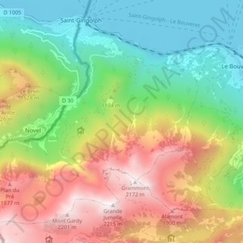
Name: Saint-Gingolph topographic map, elevation, terrain.
Location: Saint-Gingolph, Monthey, Wallis, 1898, Switzerland (46.34711 6.77063 46.39422 6.84820)
Average elevation: 1,104 m
Minimum elevation: 366 m
Maximum elevation: 2,172 m
Thank you for supporting this site ❤️
Make a donation
Make a donation
Gear up for your next adventure:
As an Amazon Associate, this site earns from qualifying purchases at no extra cost to you.