
Durach topographic map
Interactive map
Click on the map to display elevation.
About this map
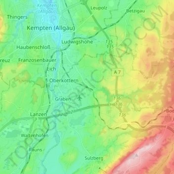
Name: Durach topographic map, elevation, terrain.
Location: Durach, Landkreis Oberallgäu, Bayern, 87471, Deutschland (47.67845 10.31885 47.71454 10.44947)
Average elevation: 758 m
Minimum elevation: 657 m
Maximum elevation: 974 m
Die Höhenlage reicht von 684 m ü. NHN an der Mündung der Durach in die Iller bis 964 m ü. NHN bei Bodelsberg.
Other topographic maps
Click on a map to view its topography, its elevation and its terrain.
Altusried
Deutschland > Bayern > Landkreis Oberallgäu
Altusried, Landkreis Oberallgäu, Bayern, 87452, Deutschland
Average elevation: 763 m
Buchenberg
Deutschland > Bayern > Landkreis Oberallgäu
Buchenberg, Landkreis Oberallgäu, Bayern, 87474, Deutschland
Average elevation: 877 m
Oberstdorf
Deutschland > Bayern > Landkreis Oberallgäu
Oberstdorf, Landkreis Oberallgäu, Bayern, 87561, Deutschland
Average elevation: 1,490 m
Sonthofen
Deutschland > Bayern > Landkreis Oberallgäu
Sonthofen, Landkreis Oberallgäu, Bayern, 87527, Deutschland
Average elevation: 964 m
Kalzhofen
Deutschland > Bayern > Landkreis Oberallgäu > Oberstaufen
Kalzhofen, Oberstaufen, Landkreis Oberallgäu, Bayern, 87534, Deutschland
Average elevation: 851 m
Oberstaufen
Deutschland > Bayern > Landkreis Oberallgäu
Oberstaufen, Landkreis Oberallgäu, Bayern, 87534, Deutschland
Average elevation: 983 m
Saneberg
Deutschland > Bayern > Landkreis Oberallgäu > Oberstaufen
Saneberg, Oberstaufen, Landkreis Oberallgäu, Bayern, 87534, Deutschland
Average elevation: 829 m
Steibis
Deutschland > Bayern > Landkreis Oberallgäu > Oberstaufen > Steibis
Steibis, Oberstaufen, Landkreis Oberallgäu, Bayern, 87534, Deutschland
Average elevation: 874 m
Hirschegg
Deutschland > Bayern > Landkreis Oberallgäu > Oberstdorf
Hirschegg, Oberstdorf, Landkreis Oberallgäu, Bayern, Deutschland
Average elevation: 1,594 m