
Make a donation
Gear up for your next adventure:
As an Amazon Associate, this site earns from qualifying purchases at no extra cost to you.
Niendorf topographic map
Click on the map to display elevation.
Make a donation
Gear up for your next adventure:
As an Amazon Associate, this site earns from qualifying purchases at no extra cost to you.
Niendorf
Niendorf liegt am Flüsschen Maurine, ca. 13 km südöstlich von Lübeck. Das hügelige Gebiet um den Ort erreicht Höhen bis zu 50 m ü. NN.
Make a donation
Gear up for your next adventure:
As an Amazon Associate, this site earns from qualifying purchases at no extra cost to you.
About this map
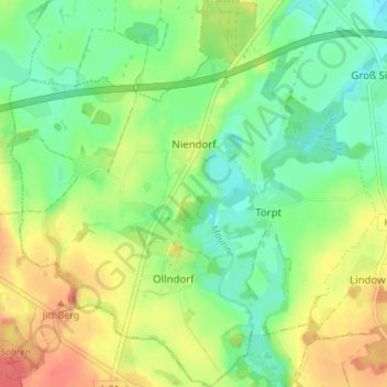
Name: Niendorf topographic map, elevation, terrain.
Average elevation: 30 m
Minimum elevation: 7 m
Maximum elevation: 61 m
Make a donation
Gear up for your next adventure:
As an Amazon Associate, this site earns from qualifying purchases at no extra cost to you.
Other topographic maps
Click on a map to view its topography, its elevation and its terrain.
Ollndorf
Deutschland > Mecklenburg-Vorpommern > Nordwestmecklenburg > Siemz-Niendorf
Average elevation: 35 m