
Make a donation
Gear up for your next adventure:
As an Amazon Associate, this site earns from qualifying purchases at no extra cost to you.
Plateau State topographic map
Click on the map to display elevation.
Make a donation
Gear up for your next adventure:
As an Amazon Associate, this site earns from qualifying purchases at no extra cost to you.
Plateau State
Plateau State is located in the North Central Zone out of the six geopolitical zones of Nigeria.[7] With an area of 26,899 square kilometres, the state has an estimated population of about three million people. It is located between latitude 08°24'N and longitude 008°32' and 010°38' east.[8] The state is named after the Jos Plateau, a mountainous area in the north of the state with rock formations.[9] Bare rocks are scattered across the grasslands, which cover the plateau.[10] The altitude ranges from around 1,200 metres (3,900 ft) to a peak of 1,829 metres (6,001 ft) above sea level in the Shere Hills range near Jos. Years of tin and columbite mining have left the area strewn with deep gorges and lakes.[11]
Make a donation
Gear up for your next adventure:
As an Amazon Associate, this site earns from qualifying purchases at no extra cost to you.
About this map
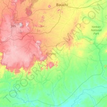
Name: Plateau State topographic map, elevation, terrain.
Location: Plateau State, Nigeria (8.36734 8.55365 10.38392 10.64004)
Average elevation: 506 m
Minimum elevation: 89 m
Maximum elevation: 1,722 m
Make a donation
Gear up for your next adventure:
As an Amazon Associate, this site earns from qualifying purchases at no extra cost to you.
Other topographic maps
Click on a map to view its topography, its elevation and its terrain.
Omu Aran
Nigeria > Kwara State > Irepodun
Omu Aran has a tropical wet and dry or savanna climate and is located at an elevation of 536.14 meters (1758.99 feet) above sea level (Classification: Aw). The district's average annual temperature is 0.26% higher than Nigeria's averages at 29.72°C (85.5°F). Omu Aran generally has 149.31 wet days per year…
Average elevation: 539 m
Ibadan
Nigeria > Oyo State > Ibadan South West
Ibadan, coined from the phrase "Eba Odan", which literally means 'by the edge of the meadow', came into existence in 1829, during a period of turmoil that characterized Yorubaland at the time. It was in this period that many old Yoruba cities such as old Oyo (Oyo ile), Ijaye and Owu disappeared, and newer ones…
Average elevation: 191 m
Make a donation
Gear up for your next adventure:
As an Amazon Associate, this site earns from qualifying purchases at no extra cost to you.