
Make a donation
Gear up for your next adventure:
As an Amazon Associate, this site earns from qualifying purchases at no extra cost to you.
Vosges topographic map
Click on the map to display elevation.
Make a donation
Gear up for your next adventure:
As an Amazon Associate, this site earns from qualifying purchases at no extra cost to you.
Vosges
In addition, the term "Central Vosges" is used to designate the various lines of summits, especially those above 1,000 m (3,300 ft) in elevation. The French department of Vosges is named after the range.
Make a donation
Gear up for your next adventure:
As an Amazon Associate, this site earns from qualifying purchases at no extra cost to you.
About this map
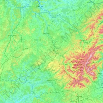
Name: Vosges topographic map, elevation, terrain.
Location: Vosges, Grand Est, Metropolitan France, France (47.81369 5.39361 48.51369 7.19837)
Average elevation: 393 m
Minimum elevation: 191 m
Maximum elevation: 1,410 m
Make a donation
Gear up for your next adventure:
As an Amazon Associate, this site earns from qualifying purchases at no extra cost to you.