
Make a donation
Gear up for your next adventure:
As an Amazon Associate, this site earns from qualifying purchases at no extra cost to you.
Gaylord topographic map
Click on the map to display elevation.
Make a donation
Gear up for your next adventure:
As an Amazon Associate, this site earns from qualifying purchases at no extra cost to you.
Gaylord
Gaylord sees significant snowfall during winter due to its elevation and its location in the path of lake-effect snow produced by Lake Michigan. Combined with local terrain and topography, many winter recreation opportunities abound.
Make a donation
Gear up for your next adventure:
As an Amazon Associate, this site earns from qualifying purchases at no extra cost to you.
About this map
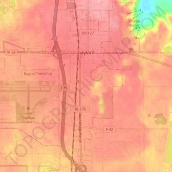
Name: Gaylord topographic map, elevation, terrain.
Location: Gaylord, Otsego County, Michigan, United States (44.98712 -84.72699 45.04505 -84.64933)
Average elevation: 401 m
Minimum elevation: 323 m
Maximum elevation: 424 m
Make a donation
Gear up for your next adventure:
As an Amazon Associate, this site earns from qualifying purchases at no extra cost to you.
Other topographic maps
Click on a map to view its topography, its elevation and its terrain.
Make a donation
Gear up for your next adventure:
As an Amazon Associate, this site earns from qualifying purchases at no extra cost to you.