
Terre Sainte topographic map
Interactive map
Click on the map to display elevation.
About this map
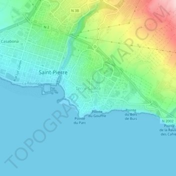
Name: Terre Sainte topographic map, elevation, terrain.
Location: Terre Sainte, Saint-Pierre, La Réunion, 97410, France (-21.36495 55.46619 -21.32495 55.50619)
Average elevation: 50 m
Minimum elevation: 0 m
Maximum elevation: 242 m
Other topographic maps
Click on a map to view its topography, its elevation and its terrain.
Mont Vert les Hauts
France > La Réunion > Saint-Pierre
Mont Vert les Hauts, Saint-Pierre, La Réunion, 97430, France
Average elevation: 589 m