
Cauldon topographic map
Click on the map to display elevation.
About this map
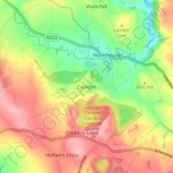
Name: Cauldon topographic map, elevation, terrain.
Average elevation: 282 m
Minimum elevation: 198 m
Maximum elevation: 366 m
Other topographic maps
Click on a map to view its topography, its elevation and its terrain.
Stepping Stones
United Kingdom > England > Staffordshire > Staffordshire Moorlands
Average elevation: 224 m
Cheddleton
United Kingdom > England > Staffordshire > Staffordshire Moorlands
Average elevation: 204 m
Biddulph Grange Country Park
United Kingdom > England > Staffordshire > Staffordshire Moorlands > Biddulph > Biddulph Moor
Average elevation: 229 m
Rudyard Lake
United Kingdom > England > Staffordshire > Staffordshire Moorlands > Rudyard > Horton
Average elevation: 205 m
Hales Hall Pool
United Kingdom > England > Staffordshire > Staffordshire Moorlands > Cheadle
Average elevation: 182 m
Waterhouses
United Kingdom > England > Staffordshire > Staffordshire Moorlands
Average elevation: 286 m
Draycott in the Moors
United Kingdom > England > Staffordshire > Staffordshire Moorlands
Average elevation: 177 m
Werrington
United Kingdom > England > Staffordshire > Staffordshire Moorlands
Average elevation: 218 m
Fawfieldhead
United Kingdom > England > Staffordshire > Staffordshire Moorlands
Average elevation: 311 m
Ladderedge Country Park
United Kingdom > England > Staffordshire > Staffordshire Moorlands > Leek
Average elevation: 176 m
Checkley
United Kingdom > England > Staffordshire > Staffordshire Moorlands > Checkley
Average elevation: 166 m
Dimmingsdale Valley
United Kingdom > England > Staffordshire > Staffordshire Moorlands > Alton
Average elevation: 177 m
Alton Castle
United Kingdom > England > Staffordshire > Staffordshire Moorlands > Alton
Average elevation: 154 m
Caverswall
United Kingdom > England > Staffordshire > Staffordshire Moorlands
Average elevation: 216 m
Consall
United Kingdom > England > Staffordshire > Staffordshire Moorlands > Consall
Average elevation: 216 m
Hollinsclough
United Kingdom > England > Staffordshire > Staffordshire Moorlands
Average elevation: 355 m
Endon Basin
United Kingdom > England > Staffordshire > Staffordshire Moorlands > Endon
Average elevation: 179 m
Alstonefield
United Kingdom > England > Staffordshire > Staffordshire Moorlands
Average elevation: 279 m
Werrington
United Kingdom > England > Staffordshire > Staffordshire Moorlands
Average elevation: 218 m
Caverswall
United Kingdom > England > Staffordshire > Staffordshire Moorlands
Average elevation: 216 m