
Thank you for supporting this site ❤️
Make a donation
Make a donation
Gear up for your next adventure:
As an Amazon Associate, this site earns from qualifying purchases at no extra cost to you.
Heathcote topographic map
Click on the map to display elevation.
Thank you for supporting this site ❤️
Make a donation
Make a donation
Gear up for your next adventure:
As an Amazon Associate, this site earns from qualifying purchases at no extra cost to you.
About this map
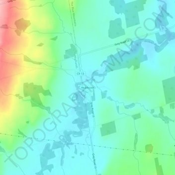
Name: Heathcote topographic map, elevation, terrain.
Average elevation: 259 m
Minimum elevation: 223 m
Maximum elevation: 367 m
Thank you for supporting this site ❤️
Make a donation
Make a donation
Gear up for your next adventure:
As an Amazon Associate, this site earns from qualifying purchases at no extra cost to you.
Other topographic maps
Click on a map to view its topography, its elevation and its terrain.
Pretty River Valley Provincial Park
Canada > Ontario > Grey County > The Blue Mountains
Average elevation: 418 m
Craigleith Provincial Park
Canada > Ontario > Grey County > The Blue Mountains
Average elevation: 215 m