
Wentworth Park topographic map
Interactive map
Click on the map to display elevation.
About this map
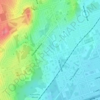
Name: Wentworth Park topographic map, elevation, terrain.
Average elevation: 214 m
Minimum elevation: 190 m
Maximum elevation: 277 m
Other topographic maps
Click on a map to view its topography, its elevation and its terrain.
Peterborough
Canada > Ontario > Peterborough
Peterborough, Ontario, K9H 7E8, Canada
Average elevation: 235 m
Otonabee River
Canada > Ontario > Peterborough
Otonabee River, Peterborough, Ontario, K9H 7N9, Canada
Average elevation: 197 m