
Make a donation
Gear up for your next adventure:
As an Amazon Associate, this site earns from qualifying purchases at no extra cost to you.
Todtnauberg topographic map
Click on the map to display elevation.
Make a donation
Gear up for your next adventure:
As an Amazon Associate, this site earns from qualifying purchases at no extra cost to you.
Todtnauberg
Der Todtnauberger Wasserfall ist mit 97 Metern Fallhöhe in fünf Fallstufen einer der höchsten Wasserfälle Deutschlands.
Make a donation
Gear up for your next adventure:
As an Amazon Associate, this site earns from qualifying purchases at no extra cost to you.
About this map
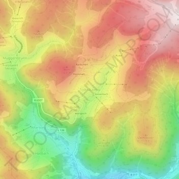
Name: Todtnauberg topographic map, elevation, terrain.
Average elevation: 1,050 m
Minimum elevation: 655 m
Maximum elevation: 1,386 m
Make a donation
Gear up for your next adventure:
As an Amazon Associate, this site earns from qualifying purchases at no extra cost to you.
Other topographic maps
Click on a map to view its topography, its elevation and its terrain.
Todtnauberg
Deutschland > Baden-Württemberg > Landkreis Lörrach > Todtnau
Der Todtnauberger Wasserfall ist mit 97 Metern Fallhöhe in fünf Fallstufen einer der höchsten Wasserfälle Deutschlands.
Average elevation: 1,117 m