
Make a donation
Gear up for your next adventure:
As an Amazon Associate, this site earns from qualifying purchases at no extra cost to you.
Shaheed Bhagat Singh Nagar topographic map
Click on the map to display elevation.
Make a donation
Gear up for your next adventure:
As an Amazon Associate, this site earns from qualifying purchases at no extra cost to you.
About this map
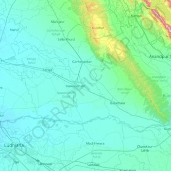
Name: Shaheed Bhagat Singh Nagar topographic map, elevation, terrain.
Location: Shaheed Bhagat Singh Nagar, Punjab, India (30.96976 75.78620 31.28392 76.51750)
Average elevation: 298 m
Minimum elevation: 235 m
Maximum elevation: 976 m
Make a donation
Gear up for your next adventure:
As an Amazon Associate, this site earns from qualifying purchases at no extra cost to you.
Other topographic maps
Click on a map to view its topography, its elevation and its terrain.
Maur
India > Punjab > Talwandi Sabo Tahsil
Maur is located at 30°05′N 75°15′E / 30.08°N 75.25°E / 30.08; 75.25.[1] It has an average elevation of 212 metres (695 feet).Situated on Bathinda Mansa road at a distance of 35 km from Bathinda, the district headquarters, Maur (also called Maur Mandi) is a railway station on the Firozpur -…
Average elevation: 216 m