
Make a donation
Gear up for your next adventure:
As an Amazon Associate, this site earns from qualifying purchases at no extra cost to you.
Buurhakaba topographic map
Click on the map to display elevation.
Make a donation
Gear up for your next adventure:
As an Amazon Associate, this site earns from qualifying purchases at no extra cost to you.
Buurhakaba
Burhakaba is situated at the coordinates of 2.7991° N, 44.0794° E with an elevation of 196 meters above sea level. It lacks a permanent river, but it does have a large valley known as "Bohol Wiinti" that runs through the town from the north, east, and south-east. After seasonal rainfall, the valley supports farming in the area it drains. The annual rainfall in the town is estimated to be 550 to 620 mm (22 to 24 in). The town is primarily populated by the Eelaay clan, a sub-clan of Rahanweyn. The main language spoken in the town is Maay, the second largest dialect in Somalia.
Make a donation
Gear up for your next adventure:
As an Amazon Associate, this site earns from qualifying purchases at no extra cost to you.
About this map
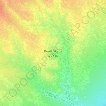
Name: Buurhakaba topographic map, elevation, terrain.
Location: Buurhakaba, Burhakaba District, Bay, South West, Somalia (2.63479 43.91845 2.95479 44.23845)
Average elevation: 203 m
Minimum elevation: 151 m
Maximum elevation: 306 m
Make a donation
Gear up for your next adventure:
As an Amazon Associate, this site earns from qualifying purchases at no extra cost to you.