
Lempira topographic map
Interactive map
Click on the map to display elevation.
About this map
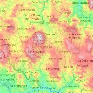
Name: Lempira topographic map, elevation, terrain.
Location: Lempira, Honduras (13.96332 -88.98200 14.94787 -88.31562)
Average elevation: 1,078 m
Minimum elevation: 105 m
Maximum elevation: 2,801 m
Other topographic maps
Click on a map to view its topography, its elevation and its terrain.
San Pedro Sula
Honduras > Cortés > San Pedro Sula
San Pedro Sula, Cortés, Honduras
Average elevation: 303 m
Río Plátano Biosphere Reserve
Río Plátano Biosphere Reserve, Brus Laguna, Gracias a Dios, Honduras
Average elevation: 179 m