
Make a donation
Gear up for your next adventure:
As an Amazon Associate, this site earns from qualifying purchases at no extra cost to you.
Antofagasta Region topographic map
Click on the map to display elevation.
Make a donation
Gear up for your next adventure:
As an Amazon Associate, this site earns from qualifying purchases at no extra cost to you.
About this map
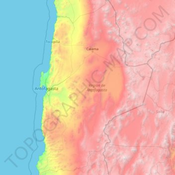
Name: Antofagasta Region topographic map, elevation, terrain.
Location: Antofagasta Region, Chile (-26.06110 -70.73714 -20.93439 -66.99052)
Average elevation: 2,361 m
Minimum elevation: 0 m
Maximum elevation: 6,437 m
Make a donation
Gear up for your next adventure:
As an Amazon Associate, this site earns from qualifying purchases at no extra cost to you.
Other topographic maps
Click on a map to view its topography, its elevation and its terrain.
Chair
Chile > Region of Magallanes and Chilean Antarctica > Provincia de la Antártica Chilena > Cape Horn
Average elevation: 18 m
Make a donation
Gear up for your next adventure:
As an Amazon Associate, this site earns from qualifying purchases at no extra cost to you.
Villa Cerro Castillo
Chile > Aysén Region > Provincia de General Carrera > Río Ibáñez
Average elevation: 379 m
San José de La Mariquina
Chile > Los Ríos Region > Provincia de Valdivia > Mariquina
Average elevation: 32 m
Baño Nuevo
Chile > Aysén Region > Provincia de Coyhaique > Coyhaique > Baño Nuevo
Average elevation: 703 m
Make a donation
Gear up for your next adventure:
As an Amazon Associate, this site earns from qualifying purchases at no extra cost to you.
Manzano Amargo
Chile > Maule Region > Provincia de Linares > Linares > Manzano Amargo
Average elevation: 415 m
Volcán San José
Chile > Santiago Metropolitan Region > Provincia de Cordillera > San José de Maipo
Average elevation: 5,462 m