
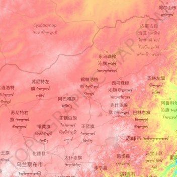
锡林郭勒盟 ᠰᠢᠯᠢ ᠶᠢᠨ ᠭᠣᠣᠯ ᠠᠶᠢᠮᠠᠭ topographic map
Interactive map
Click on the map to display elevation.
About this map
Name: 锡林郭勒盟 ᠰᠢᠯᠢ ᠶᠢᠨ ᠭᠣᠣᠯ ᠠᠶᠢᠮᠠᠭ topographic map, elevation, terrain.
Location: 锡林郭勒盟 ᠰᠢᠯᠢ ᠶᠢᠨ ᠭᠣᠣᠯ ᠠᠶᠢᠮᠠᠭ, Innere Mongolei, 692485, China (41.56931 111.15601 46.77579 119.89882)
Average elevation: 1,058 m
Minimum elevation: 220 m
Maximum elevation: 2,203 m
Other topographic maps
Click on a map to view its topography, its elevation and its terrain.
巴日嘎斯台乡
巴日嘎斯台乡, 科尔沁右翼前旗 ᠬᠣᠷᠴᠢᠨ ᠪᠠᠷᠠᠭᠤᠨ ᠭᠠᠷᠤᠨ ᠡᠮᠦᠨᠡᠳᠦ ᠬᠣᠰᠢᠭᠤ, Hinggan, Innere Mongolei, China
Average elevation: 451 m
白石头村
China > Innere Mongolei > Ulanqab
白石头村, Ulanqab, Innere Mongolei, China
Average elevation: 1,479 m
鄂尔多斯市
China > Innere Mongolei > 鄂尔多斯市 > 青春山街道
鄂尔多斯市, 青春山街道, Kang Baschi, Ордос / 鄂尔多斯市 / Ordos, Innere Mongolei, 017010, China
Average elevation: 1,372 m
锡林街道
China > Innere Mongolei > Erenhot > 锡林街道
锡林街道, Erenhot, Innere Mongolei, China
Average elevation: 962 m
Ордос / 鄂尔多斯市 / Ordos
Ордос / 鄂尔多斯市 / Ordos, Innere Mongolei, China
Average elevation: 1,260 m