
Make a donation
Gear up for your next adventure:
As an Amazon Associate, this site earns from qualifying purchases at no extra cost to you.
Unterrot topographic map
Click on the map to display elevation.
Make a donation
Gear up for your next adventure:
As an Amazon Associate, this site earns from qualifying purchases at no extra cost to you.
About this map
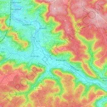
Name: Unterrot topographic map, elevation, terrain.
Average elevation: 416 m
Minimum elevation: 321 m
Maximum elevation: 517 m
Make a donation
Gear up for your next adventure:
As an Amazon Associate, this site earns from qualifying purchases at no extra cost to you.
Other topographic maps
Click on a map to view its topography, its elevation and its terrain.
Winzenweiler
Deutschland > Baden-Württemberg > Landkreis Schwäbisch Hall > Gaildorf
Average elevation: 469 m
Schlosspark
Deutschland > Baden-Württemberg > Landkreis Schwäbisch Hall > Gaildorf > Münster
Average elevation: 365 m
Reippersberg
Deutschland > Baden-Württemberg > Landkreis Schwäbisch Hall > Gaildorf > Unterrot
Average elevation: 423 m
Münster
Deutschland > Baden-Württemberg > Landkreis Schwäbisch Hall > Gaildorf
Average elevation: 396 m
Make a donation
Gear up for your next adventure:
As an Amazon Associate, this site earns from qualifying purchases at no extra cost to you.