Geolocate

Greete topographic map

Click on the map to display elevation.

About this map

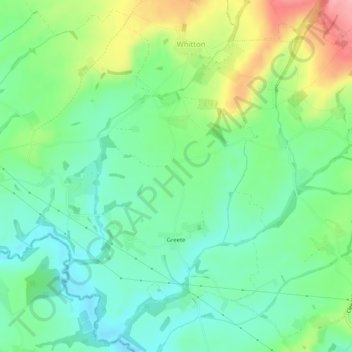
Name: Greete topographic map, elevation, terrain.

Location: Greete, Shropshire, England, United Kingdom (52.32420 -2.66316 52.35371 -2.61232)

Average elevation: 106 m

Minimum elevation: 65 m

Maximum elevation: 189 m

Other topographic maps

Click on a map to view its topography, its elevation and its terrain.

Cross Houses

United Kingdom > England > Shropshire

Average elevation: 62 m

Snailbeach

United Kingdom > England > Shropshire

Average elevation: 248 m

Oswestry

United Kingdom > England > Shropshire

Average elevation: 158 m

Gear up for your next adventure:

🛰️Handheld GPS Units - Professional satellite navigation for Irish highlands
🧥Waterproof Hiking Jackets - Rain jackets for unpredictable weather
🩰Hiking Binoculars - See long distances on trails
🛠️Tent Repair Kits - Fix tents on the trail
📍Trail Markers & GPS - Tools to track and mark trails

As an Amazon Associate, this site earns from qualifying purchases at no extra cost to you.