
Make a donation
Gear up for your next adventure:
As an Amazon Associate, this site earns from qualifying purchases at no extra cost to you.
Burnet topographic map
Click on the map to display elevation.
Make a donation
Gear up for your next adventure:
As an Amazon Associate, this site earns from qualifying purchases at no extra cost to you.
About this map
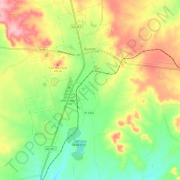
Name: Burnet topographic map, elevation, terrain.
Location: Burnet, Burnet County, Texas, United States (30.69130 -98.27983 30.78552 -98.16564)
Average elevation: 404 m
Minimum elevation: 334 m
Maximum elevation: 491 m
Make a donation
Gear up for your next adventure:
As an Amazon Associate, this site earns from qualifying purchases at no extra cost to you.
Other topographic maps
Click on a map to view its topography, its elevation and its terrain.
Make a donation
Gear up for your next adventure:
As an Amazon Associate, this site earns from qualifying purchases at no extra cost to you.
Marble Falls
United States > Texas > Burnet County > Marble Falls > Marble Falls
Average elevation: 261 m